
Sheffield, Iowa facts for kids
Quick facts for kids
Sheffield, Iowa
|
|
|---|---|
 |
|

Location of Sheffield, Iowa
|
|
| Country | |
| State | |
| County | Franklin |
| Area | |
| • Total | 5.60 sq mi (14.50 km2) |
| • Land | 5.57 sq mi (14.42 km2) |
| • Water | 0.03 sq mi (0.07 km2) |
| Elevation | 1,076 ft (328 m) |
| Population
(2020)
|
|
| • Total | 1,130 |
| • Density | 202.95/sq mi (78.35/km2) |
| Time zone | UTC-6 (Central (CST)) |
| • Summer (DST) | UTC-5 (CDT) |
| ZIP code |
50475
|
| Area code(s) | 641 |
| FIPS code | 19-72210 |
| GNIS feature ID | 0461552 |
| Website | www.sheffieldiowa.com |
Sheffield is a small city located in Franklin County, Iowa, in the United States. In 2020, about 1,130 people lived there.
Contents
Sheffield's Beginnings: A Look at Its History
Sheffield was officially planned out in 1874. It was named after a close friend of the person who founded the city. Just two years later, in 1876, Sheffield became an incorporated city. This means it was officially recognized as a town with its own local government.
Where is Sheffield? Geography and Location
Sheffield, Iowa, is located at coordinates 42.893649 degrees North and -93.217067 degrees West.
The city covers a total area of about 5.58 square miles (14.45 square kilometers). Most of this area, about 5.55 square miles (14.37 square kilometers), is land. A very small part, about 0.03 square miles (0.07 square kilometers), is water.
Who Lives in Sheffield? Population Facts
| Historical populations | ||
|---|---|---|
| Year | Pop. | ±% |
| 1880 | 307 | — |
| 1890 | 610 | +98.7% |
| 1900 | 688 | +12.8% |
| 1910 | 824 | +19.8% |
| 1920 | 1,106 | +34.2% |
| 1930 | 1,057 | −4.4% |
| 1940 | 1,060 | +0.3% |
| 1950 | 1,163 | +9.7% |
| 1960 | 1,156 | −0.6% |
| 1970 | 1,070 | −7.4% |
| 1980 | 1,224 | +14.4% |
| 1990 | 1,174 | −4.1% |
| 2000 | 930 | −20.8% |
| 2010 | 1,172 | +26.0% |
| 2020 | 1,130 | −3.6% |
| Source: and Iowa Data Center Source: |
||
Population in 2020
In 2020, the city of Sheffield had 1,130 people living in 472 households. About 314 of these were families. The city had about 203 people per square mile.
Most of the people living in Sheffield were White (93.6%). A smaller number were Black or African American (0.8%), Native American (0.2%), or Asian (0.6%). About 4.2% of residents were from two or more races. Hispanic or Latino people made up 1.6% of the population.
About 29% of households had children under 18 living with them. The average age in the city was 43.3 years old. About 23.7% of residents were under 20 years old.
Population in 2010
In 2010, Sheffield had 1,172 people living in 480 households. The population density was about 211 people per square mile.
Most residents (98.2%) were White. Other groups included African American (0.2%), Native American (0.3%), and Asian (0.5%). Hispanic or Latino people made up 0.9% of the population.
About 27.7% of households had children under 18. The average age in the city was 44.6 years. About 23.5% of residents were under 18 years old.
Learning in Sheffield: School Districts
Sheffield is part of the West Fork Community School District. This district was created in 2011 when two smaller school districts merged. These were the Sheffield–Chapin–Meservey–Thornton (SCMT) Community School District and the Rockwell–Swaledale Community School District.
The SCMT district itself was formed in 2007 from an earlier merger. Before that, the Sheffield–Chapin Community School District and the Meservey–Thornton Community School District joined together. The Sheffield–Chapin district was formed in 1960 from the Sheffield Community School District and the Chapin Community School District.
Famous Faces: Notable People from Sheffield
- Fred Schwengel: He was a politician who represented Iowa's 1st congressional district in the U.S. Congress for more than ten years.
Images for kids
-
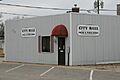
Sheffield City Hall
-
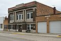
Buildings in downtown Sheffield


See also
 In Spanish: Sheffield (Iowa) para niños
