Shima Tract facts for kids

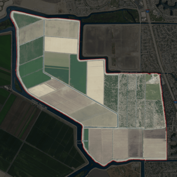
USGS aerial imagery of the Shima Tract
|
|
| Geography | |
|---|---|
| Location | Northern California |
| Coordinates | 38°01′40″N 121°23′06″W / 38.02778°N 121.38500°W |
| Adjacent bodies of water | Sacramento–San Joaquin River Delta |
| Highest elevation | 0 ft (0 m) |
| Administration | |
|
United States
|
|
| State | |
| County | San Joaquin |
The Shima Tract is a special piece of land, like an island, located in a big watery area called the Sacramento–San Joaquin River Delta in California. It's part of San Joaquin County.
Discovering Shima Tract
Shima Tract is a unique island in the Sacramento–San Joaquin River Delta. This delta is a huge area where the Sacramento and San Joaquin rivers meet. It's an important natural area in Northern California.
Where is Shima Tract Located?
This island is found in the northern part of California. It's within San Joaquin County. The exact spot can be found using its coordinates: 38°01′40″N 121°23′06″W / 38.02778°N 121.38500°W.
In 1981, the United States Geological Survey (USGS) measured the island's height. They found that Shima Tract is at 0 ft (0 m) above sea level. This means it's very flat, almost at the same level as the water around it.
Who Manages Shima Tract?
Shima Tract is managed by a group called Reclamation District 2115. A reclamation district is like a special local government. Their job is to manage water and land in certain areas. They often work to protect land from floods or to help with farming.


