Shin Kee Tract facts for kids

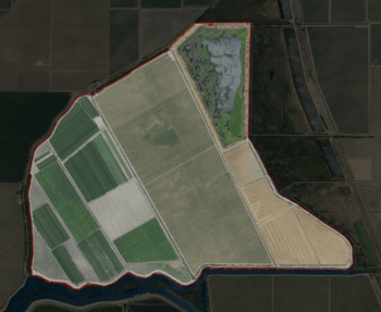
USGS aerial imagery of the Shin Kee Tract
|
|
| Geography | |
|---|---|
| Location | Northern California |
| Coordinates | 38°05′45″N 121°25′09″W / 38.09583°N 121.41917°W |
| Adjacent bodies of water | Sacramento–San Joaquin River Delta |
| Highest elevation | 0 ft (0 m) |
| Administration | |
|
United States
|
|
| State | |
| County | San Joaquin |
The Shin Kee Tract is a small island located in the Sacramento–San Joaquin River Delta in California. It's part of San Joaquin County. The island's elevation was measured at 0 feet (0 meters) in 1981 by the United States Geological Survey.
What is the Shin Kee Tract?
The Shin Kee Tract is an island. It is found in a special area called the Sacramento–San Joaquin River Delta. This delta is where the Sacramento and San Joaquin rivers meet. They flow into San Francisco Bay.
Where is this Island Located?
The Shin Kee Tract is in Northern California. It is part of San Joaquin County. This county is in the central part of California.
How High is the Island?
The United States Geological Survey (USGS) measured the island's height. In 1981, they found its elevation to be 0 feet (0 meters). This means the island is at sea level. The USGS is a science agency. They study the land, water, and natural resources.


