Shire of Kent facts for kids
Quick facts for kids Shire of KentWestern Australia |
|||||||||||||||
|---|---|---|---|---|---|---|---|---|---|---|---|---|---|---|---|

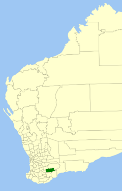
Location in Western Australia
|
|||||||||||||||
| Established | 1922 | ||||||||||||||
| Area | 5,633.8 km2 (2,175.2 sq mi) | ||||||||||||||
| Shire President | Scott Crosby | ||||||||||||||
| Council seat | Nyabing | ||||||||||||||
| Region | Great Southern | ||||||||||||||
| State electorate(s) | Roe | ||||||||||||||
| Federal Division(s) | O'Connor | ||||||||||||||
 |
|||||||||||||||
| Website | Shire of Kent | ||||||||||||||
|
|||||||||||||||
The Shire of Kent is a special area in Western Australia that has its own local government. Think of it like a big neighborhood or district that manages its own local services. It's located in the Great Southern region, about 320 kilometers (200 miles) southeast of Perth, which is the capital city of Western Australia.
This Shire covers a large area of about 5,634 square kilometers (2,175 square miles). The main town where the local government offices are located is called Nyabing. The land in the Shire of Kent is mostly used for farming. Farmers here grow important crops like wheat, barley, and other legumes.
Contents
A Look Back: The Shire's History
The Shire of Kent has an interesting history, changing its name a few times.
How the Shire Began
The area first got its own local management on December 22, 1922. Back then, it was called the Kent Road District. A "Road District" was an early type of local government mainly focused on building and maintaining roads.
Later, on June 10, 1955, its name changed to the Nyabing-Pingrup Road District. This new name included two of the main towns in the area.
Becoming a Shire
The way local governments worked in Western Australia changed in 1960. A new law, the Local Government Act 1960, made all Road Districts become "Shires." So, on July 1, 1961, the Nyabing-Pingrup Road District officially became the Shire of Nyabing-Pingrup.
However, the name changed back again! On December 1, 1972, it returned to its original, shorter name: the Shire of Kent.
Where the Name "Kent" Comes From
The name "Kent" was chosen to honor a person from an early expedition. It comes from a commissariat officer (someone in charge of supplies) who was part of Dr. T. Wilson's journey in 1829.
How the Shire is Organized: Wards and Councillors
To help manage such a large area, the Shire of Kent is divided into smaller sections called "wards." Each ward has people called "councillors" who are elected by the community to represent them. These councillors work together to make decisions for the whole Shire.
Understanding Wards
In 2002, the Shire was divided into four main wards. Each of these wards elects two councillors. This means that people living in each ward have a voice in the local government.
- Holland Rock Ward
- Mindarabin Ward
- Nampup Ward
- Pingarnup Ward
Towns and Localities in the Shire
The Shire of Kent includes several towns and smaller areas known as "localities." These are the places where people live and work within the Shire. The two main towns are Nyabing and Pingrup.
Here are the main towns and localities, along with how many people live in them and their size, based on the most recent count:
| Locality | Population | Area | Map |
|---|---|---|---|
| Nyabing | 260 (SAL 2021) | [convert: needs a number] | |
| Pingrup | 231 (SAL 2021) | [convert: needs a number] |
Protecting Old Places: Heritage Sites
The Shire of Kent cares about its history and old buildings. As of 2021, there are 73 places in the Shire that are recognized as "heritage-listed." This means they are important historical sites that need to be protected. None of these places are currently on the State Register of Heritage Places, which is a special list of the most important historical sites in the state.
 | Kyle Baker |
 | Joseph Yoakum |
 | Laura Wheeler Waring |
 | Henry Ossawa Tanner |

