Shire of Upper Gascoyne facts for kids
Quick facts for kids Shire of Upper GascoyneWestern Australia |
|||||||||||||||
|---|---|---|---|---|---|---|---|---|---|---|---|---|---|---|---|

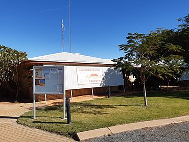
The Shire of Upper Gascoyne administration office
|
|||||||||||||||

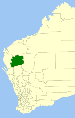
Location in Western Australia
|
|||||||||||||||
| Established | 1887 | ||||||||||||||
| Area | 57,939 km2 (22,370.4 sq mi) | ||||||||||||||
| Shire President | Don Hammmarquist | ||||||||||||||
| Council seat | Gascoyne Junction | ||||||||||||||
| Region | Gascoyne region | ||||||||||||||
| State electorate(s) | North West | ||||||||||||||
| Federal Division(s) | Durack | ||||||||||||||
 |
|||||||||||||||
| Website | Shire of Upper Gascoyne | ||||||||||||||
|
|||||||||||||||
The Shire of Upper Gascoyne is a special kind of local government area in Western Australia. It is located inland from Carnarvon. This area is about 1,000 kilometres (620 mi) north of Perth, the state capital.
The Shire covers a huge area of 57,939 square kilometres (22,370 sq mi). Much of this land is empty or has very few plants. It is mostly sheep station country. The main town and government centre is Gascoyne Junction. In 2021, about 170 people lived here. More than half of them (56%) are Aboriginal people.
Contents
History of the Shire
The Upper Gascoyne Road District was created on 10 February 1887. A "Road District" was an early type of local government. It was mainly in charge of building and looking after roads.
On 1 July 1961, the Road District changed its name. It became the Shire of Upper Gascoyne. This happened because of a new law called the Local Government Act 1960. This law turned all old road districts into shires. The first office building of the Road Board is still standing. It is now a special place protected for its history.
How the Shire is Governed
The Shire of Upper Gascoyne is divided into three main areas. These areas are called wards. Each ward has two people who help run the Shire. These people are called councillors.
- North Ward
- South Ward
- East Ward
Towns and Localities
The Shire of Upper Gascoyne has a few towns and areas. Here are some of them, with how many people lived there in 2021:
| Suburb | Population (2021) | Area (km²) | Map |
|---|---|---|---|
| East Lyons River | 13 | 10,757 | |
| Gascoyne Junction | 65 | 1,079 | |
| Gascoyne River | 87 | 29,394 | |
| West Lyons River | 0 | 16,709 |
Important Councillors
Some people who were once councillors for the Upper Gascoyne Road Board later became important. They went on to become members of the state parliament.
- Everard Darlot: He was a Road Board member in 1887. Later, he became a state Member of Parliament (MP).
- Lionel Kelly: He was a Road Board member from 1927 to 1928. He also later became a state MP.
Places with Special History
As of 2024, there are 19 places in the Shire of Upper Gascoyne that are considered heritage-listed. This means they are important historical sites. They are protected so people can learn about the past.
One of the most important heritage-listed places is the Upper Gascoyne Road Board Office. It is located in Gascoyne Junction. This building is even listed on the State Register of Heritage Places.
 | Claudette Colvin |
 | Myrlie Evers-Williams |
 | Alberta Odell Jones |

