
Shornemead Fort facts for kids
Quick facts for kids Shornemead Fort |
|
|---|---|
| close to Higham, Kent | |

View of the exterior of the casemates of Shornemead Fort
|
|

Shornemead Fort
|
|
| Coordinates | 51°26′48″N 0°26′03″E / 51.446768°N 0.434059°E |
| Type | Fortification |
| Site information | |
| Controlled by | Royal Society for the Protection of Birds |
| Open to the public |
Yes |
| Condition | Mostly demolished |
| Site history | |
| Built | ca. 1861–70 |
| Built by | United Kingdom |
| In use | 1870–1950s |
| Materials | Concrete, granite |
| Demolished | 1960s |
| Battles/wars | First World War, Second World War |
Shornemead Fort was a strong building, like a castle, built in the 1860s. Its job was to protect the entrance of the River Thames from enemy ships. It was built when there was some tension with France. The fort stands on the south side of the river. From its location, it had a great view up and down the Thames.
This fort was the third one built in this spot since the 1700s. However, it was built on marshy ground, which caused big problems. The ground kept sinking, making the fort unsafe. It had powerful artillery guns, meant to help two other forts nearby. But because of the sinking ground, it became too dangerous to fire the guns. The fort's guns were removed by the early 1900s.
Shornemead Fort was used from 1870 until the 1950s. Most of it was torn down in the 1960s by the Army. The living quarters and offices are completely gone. Only the front part of the casemates (gun rooms) remains. The magazines (where ammunition was stored) are still underneath. However, they are now flooded and cannot be reached. The parts of the fort that are left are now part of a nature reserve. People can visit the site today.
Contents
Building the Fort
Why a New Fort?
The third and final Shornemead Fort was built between 1861 and 1870. It cost a lot of money to build. This new fort was much bigger than the ones before it. It replaced older, weaker gun positions. The new fort had very strong casemates. These were rooms designed to protect the guns and soldiers from enemy fire.
Strong Walls and Design Challenges
The walls of the casemates were very thick. They were over 635 millimeters (about 25 inches) thick. They had layers of steel and wood, covered with strong granite stone. The first plans wanted to put fourteen guns on the fort's roof. They also planned for twenty-two guns inside the casemates at ground level.
But the marshy ground caused problems again. The ground kept sinking, just like with earlier forts. Because of this, the original design could not be fully built. The plans had to be changed a lot in 1867, even while construction was happening.
- Plans of Shornemead Fort
-
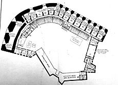
Plan of the upper (casemates) level
-
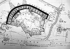
Plan of the lower (magazines) level


Final Layout of the Fort
In the end, the idea of putting guns on the roof was dropped. Instead, eleven casemates were built in a curve. They faced downriver, ready to fire at ships coming up the Thames. An open area for three more guns was at the west end. These guns pointed upriver towards Gravesend and Tilbury. Their job was to help older forts in those towns.
A single-story barracks (soldiers' living quarters) was built at the back of the fort. It had small openings for soldiers to shoot through. This helped protect the fort from attacks from the land side. Three small forts called caponiers guarded the edges of the fort. A large open area was in the middle. There used to be a ditch in front of the casemates, but it was filled in during the 1880s. Underneath the casemates were magazines. These were rooms for storing shells and cartridges.
Fort in Action
Guns and Defenses

When it was finished, Shornemead Fort had eleven large 11-inch guns. These guns could fire shells up to 5.5 kilometers (about 3.4 miles). They were inside the casemates. Three other 9-inch guns were in the open area. All these guns were on special mounts. These mounts helped absorb the powerful kickback when the guns fired. They could also be moved to aim in different directions.
In 1895, two smaller, faster-firing guns were added. These were meant to protect a minefield that would be placed in the river if there was a war. Powerful searchlights were also set up nearby. These lights would help spot enemy ships at night. A special base for laying underwater mines was also built west of the fort.
When the Guns Went Silent
Between 1895 and 1907, the guns at Shornemead Fort were removed. The ground sinking had made the fort unsafe for firing its big guns. Also, by then, the fort was no longer as important for defense. For a while, it was used as a training place for soldiers. These soldiers learned about laying underwater mines.
The fort was temporarily given guns again in 1913. Two 12-pounder guns were placed outside the fort. In 1941, during World War II, it became an emergency battery. Two 5.5-inch naval guns were installed in the same spots. These guns had concrete shelters to protect them. A special landing area was built by the river. This was to help with the D-Day invasion. Old photos show the fort and guns surrounded by lots of barbed wire. The fort was put on "care and maintenance" in 1943. The guns were removed in 1945, and their shelters were torn down around 1976.
Life at the Fort
The barracks at Shornemead Fort were used by soldiers for many years. They trained at a nearby rifle range. There was a permanent staff living at the fort. The barracks had classrooms, living spaces, and even a swimming pool. After World War II, the fort was no longer needed. It was torn down in the 1960s by the Army as a training exercise. The remaining buildings were demolished in the 1970s.
What's Left Today?

Today, most of Shornemead Fort is gone. Only the front part of the casemates can be seen above ground. Some cleanup has been done, but the ruins are open to damage. Nothing is left of the barracks or offices. The magazines are still underground, but they are flooded. They were sealed off in 2008.
The public can visit the site. It is now part of the Royal Society for the Protection of Birds' Shorne Marshes Nature Reserve. A concrete road, built by the military, leads to the fort from Lower Higham Road. The Saxon Shore Way walking path also goes past the fort.
Images for kids
-
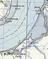
Map of the area of Cliffe, Coalhouse and Shornemead Forts

