
Sierra de Híjar facts for kids
Quick facts for kids Sierra de Híjar |
|
|---|---|

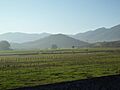
The Sierra de Híjar range, viewed from Valdecebollas. In the foreground, the peaks of Peña Labra, Tres Mares, and Cuchillón are visible. In the background, Peña Agujas, Cueva del Cobre, and the Picos de Europa.
|
|
| Highest point | |
| Peak | Cuchillón |
| Elevation | 2,179–2,222 metres (7,149–7,290 ft) |
| Dimensions | |
| Length | 24 km (15 mi) NNW |
| Area | 0.16 km2 (0.062 sq mi) |
| Geography | |

Location of the Sierra de Híjar
|
|
| Country | Spain |
| Parent range | Cantabrian Mountains |


The Sierra de Híjar is a mountain range in northern Spain. It is part of the larger Cantabrian Mountains system. You can find it in the Province of Palencia and the Autonomous Community of Cantabria.
Contents
Exploring the Sierra de Híjar Mountains
This mountain range stretches for about 24 kilometres (15 mi). It runs from the west-northwest to the east-southeast. The tallest peaks are in the middle and northeastern parts of the range. From there, the mountains get lower. The widest part of the range is about 5,200 metres (3.2 mi) across.
The highest point in the Sierra de Híjar is Cuchillón. Its exact height can vary a little depending on the source. Some maps say it's 2,174 metres (7,133 ft) tall. Other sources, like some from the National Geographic Institute of Spain, say it's 2,222 metres (7,290 ft).
This mountain range forms a natural border. It separates the Campoo region in Cantabria from the La Pernia region in Palencia. It is one of the southernmost parts of the Cantabrian Mountains. It is also the last part of the range to rise above 2,000 metres (6,600 ft).
What are the Main Peaks in Sierra de Híjar?
The tallest mountains are found in the central area. These include famous peaks like Tres Mares and Cueto Manin. In the northwestern part, you'll find the long ridge of Peña Labra. You can even reach its summit from Polaciones.
The southeastern part of the range is lower. It stretches from Sestil to Alto de Hoyos. This area is sometimes called the Cinto Brotherhood.
Here are some of the main peaks, listed from northwest to southeast:
| Name, altitude | Coordinates | Notes |
|---|---|---|
| Peña Labra, 2029 m | 43°02′44″N 4°25′55″W / 43.04556°N 4.43194°W | This peak has a special measuring station. It marks the end of a flat area that reaches 2000 meters high. |
| Tres Mares, 2171 m | 43°02′16″N 4°24′14″W / 43.03778°N 4.40389°W | The top has a flat area like a terrace. It offers amazing views of the surroundings. |
| Las Hoyas, 2106 m | 43°01′50″N 4°23′39″W / 43.03056°N 4.39417°W | |
| Cuchillón, 2174–2222 m | 43°01′36″N 4°23′27″W / 43.02667°N 4.39083°W | This is the highest point in the whole range. People also call it "Canchal de la Muela" or "Rock of Pando" because its top is quite flat. |
| Cotomañinos or Guzmerones, 2144 m | 43°00′35″N 4°22′42″W / 43.00972°N 4.37833°W | This peak and the one before it form a valley shaped by glaciers. |
| Cueto Mañín, 2122 m | 43°00′19″N 4°22′28″W / 43.00528°N 4.37444°W | Peña de las Agujas is on the southern side of this mountain. |
| Valdecebollas, 2143 m | 42°58′00″N 4°21′54″W / 42.96667°N 4.36500°W | This peak is on a ridge south of the main mountain line. |
| Sestil, 2065 m | 42°58′20″N 4°20′53″W / 42.97222°N 4.34806°W | Between this point and Cueto Manin, you'll find an area called Sel de la Fuente. |
| Peña Rubia, 1937 m | 42°57′58″N 4°18′00″W / 42.96611°N 4.30000°W | This peak forms a long ridge where the Camesa river begins. |
| Cuesta Labra, 1951 m | 42°58′00″N 4°16′55″W / 42.96667°N 4.28194°W | On its north side are two valleys shaped by glaciers, Bucer and Vitor. To the east, it connects with Peña Ensillada towards Somahoz. |
Why is it Called Sierra de Híjar?
Sometimes, people call this mountain system "Peña Labra." This is especially true when looking at it from the south. From that direction, the peak of Peña Labra stands out the most. However, it's not the tallest mountain in the range.
Older maps and studies, including early ones from the National Geographic Institute of Spain, always called this area "Sierra de Híjar." So, "Sierra de Híjar" is the official and historical name for this mountain range.
Images for kids
-
Sierra de Híjar (right) from Reinosa.
-
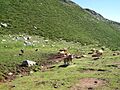
Cows on brañas of Sestil.


See also
 In Spanish: Sierra de Híjar para niños
