
Silva Island facts for kids

An aerial photo taken in 2013, looking toward the east.
|
|

Silva Island
Location in San Francisco Bay Area

Silva Island
Location in California

Silva Island
Location in the United States
|
|
| Geography | |
|---|---|
| Location | Northern California |
| Coordinates | 37°53′15″N 122°30′54″W / 37.88750°N 122.51500°W |
| Adjacent bodies of water | San Francisco Bay |
| Highest elevation | 79 ft (24.1 m) |
| Administration | |
|
United States
|
|
| State | |
| County | Marin |
Silva Island is a small piece of land located in San Francisco Bay. It is found in Marin County, California.
This island was once completely surrounded by water. However, over time, it has become mostly connected to the mainland.
Its exact location is 37°53′15″N 122°30′54″W / 37.88750°N 122.51500°W. In 1981, the United States Geological Survey measured its highest point. They found that Silva Island is about 79 ft (24 m) above sea level.
What is Silva Island?
Silva Island is an island in the large body of water known as San Francisco Bay. An island is a piece of land that is surrounded by water. However, Silva Island is a bit special because it is now mostly joined to the land nearby.
How Islands Can Change
Islands can change over many years. Sometimes, land can be added around them, or the water levels can change. This can make an island connect to the mainland. For Silva Island, it means you can now reach most of it without crossing water.
Looking at Maps of Silva Island
Maps help us see how places change over time. The maps below show Silva Island at different points in history. You can see how its shape and connection to the mainland might have looked.
-
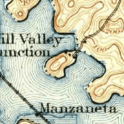
This map from 1897 shows Silva Island a long time ago.
-
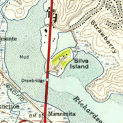
This map from 1954 shows how the island looked later.


