Sixaola River facts for kids
Quick facts for kids Río Sixaola |
|
|---|---|

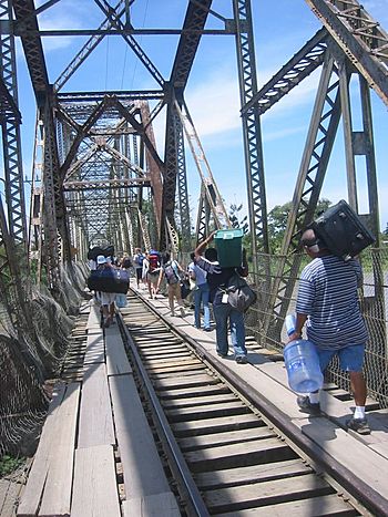
Crossing the river at the Panama border. This bridge doesn't exist anymore.
|
|
|
Location of mouth
|
|
| Countries | |
| Physical characteristics | |
| Main source | Cordillera Talamanca La Amistad International Park, Limón Province, Costa Rica |
| River mouth | Caribbean Sea, Costa Rica 0 m (0 ft) 9°34′20″N 82°33′54″W / 9.57222°N 82.56500°W |
| Discharge (location 2) |
|
The Sixaola River (called Río Sixaola in Spanish) is an important river in Central America. It flows through the southern part of Limón Province in Costa Rica. This river starts high up in the mountains and ends in the Caribbean Sea.
The Sixaola River is special because it forms part of the border between two countries: Costa Rica and Panama. This means it helps mark where one country ends and the other begins.
Contents
Where Does the Sixaola River Start and End?
The Sixaola River begins in the Cordillera Talamanca mountain range. This area is part of a special protected place called La Amistad International Park. The park is shared by both Costa Rica and Panama.
From the mountains, the river flows northeast. It eventually reaches the Caribbean Sea near a town also named Sixaola. The mouth of the river, where it meets the sea, is at coordinates 9°34′20″N 82°33′54″W / 9.57222°N 82.56500°W.
The River as a Border
For a good part of its journey, the Sixaola River acts as a natural border. It separates Limón Province in Costa Rica from Bocas del Toro Province in Panama. This makes it a key landmark for people traveling between the two nations.
Bridges Over the Sixaola
For many years, an old railroad bridge crossed the river. It connected the town of Sixaola in Costa Rica with Guabito in Panama. People often walked across this bridge to go between the two countries. However, this old bridge collapsed in 2017 and has since been taken down.
A new road bridge was built next to where the old one stood. This new bridge opened in 2020. It helps connect National Route 36 in Costa Rica with Route 1001 in Panama. This makes travel and trade easier between the two countries.
Time Zone Border
The Sixaola River also marks a change in time zones. On the Costa Rican side, it's UTC−06:00, which is the Central Time Zone. On the Panamanian side, it's UTC−05:00, the Eastern Time Zone. This means Costa Rica is one hour behind Panama. So, when you cross the river, you might need to change your watch!
See also
 In Spanish: Río Sixaola para niños
 | Jessica Watkins |
 | Robert Henry Lawrence Jr. |
 | Mae Jemison |
 | Sian Proctor |
 | Guion Bluford |


