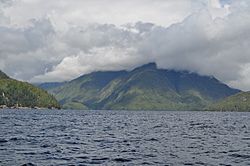
Skidegate Channel facts for kids
Quick facts for kids Skidegate Channel |
|
|---|---|

View up Dawson Inlet from Skidegate Channel
|
|
| Location | Haida Gwaii, British Columbia, Canada |
| Coordinates | 53°9′N 132°20′W / 53.150°N 132.333°W |
| Type | Channel |
| Ocean/sea sources | Pacific Ocean |
| Max. length | 33 kilometres (21 mi) |
| Max. width | 4.3 kilometres (2.7 mi) |
The Skidegate Channel is a narrow waterway in British Columbia, Canada. It is part of the Haida Gwaii islands. This channel separates the two main islands of the group. These are Graham Island to the north and Moresby Island to the south.
Where is Skidegate Channel?
Skidegate Channel is located in a special place. It lies between Graham Island on its north side. To the south is Moresby Island. The Pacific Ocean is to its west. To the northeast, it connects to Skidegate Inlet.
How Big is the Channel?
The channel is about 33 kilometers (21 miles) long. Its widest part is about 4.3 kilometers (2.7 miles) across. But it gets very narrow in one spot. This narrowest part is called East Narrows. Here, the channel is only about 65 meters (213 feet) wide.
What are the Inlets?
Two smaller waterways branch off from Skidegate Channel. These are called inlets. An inlet is a small arm of the sea, lake, or river.
- Dawson Inlet branches off to the north. It is close to where Skidegate Channel meets the Pacific Ocean.
- Trounce Inlet also branches off to the north. It is about halfway along the channel's length.
 | Dorothy Vaughan |
 | Charles Henry Turner |
 | Hildrus Poindexter |
 | Henry Cecil McBay |


