Smith, Alberta facts for kids
Quick facts for kids
Smith
|
|
|---|---|
| Country | Canada |
| Province | Alberta |
| Region | Northern Alberta |
| Census division | 17 |
| Municipal district | Municipal District of Lesser Slave River No. 124 |
| Government | |
| • Type | Unincorporated |
| Area
(2021)
|
|
| • Land | 2.42 km2 (0.93 sq mi) |
| Population
(2021)
|
|
| • Total | 227 |
| • Density | 93.7/km2 (243/sq mi) |
| Time zone | UTC−07:00 (MST) |
| • Summer (DST) | UTC−06:00 (MDT) |
| Area code(s) | 780, 587, 825 |
| Waterways | Athabasca River, Lesser Slave River |
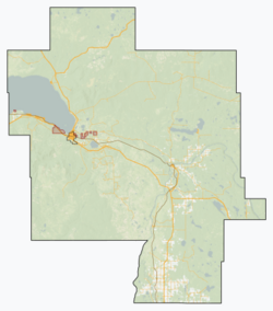
Smith is a small community called a hamlet in northern Alberta, Canada. It's part of the Municipal District of Lesser Slave River No. 124. You can find Smith on Highway 2A. It's about 182 kilometers (113 miles) northwest of Edmonton. Smith is special because it sits where the Lesser Slave River meets the Athabasca River.
Smith's Story
The community of Smith started in 1914. This happened when the Edmonton, Dunvegan and British Columbia Railway reached the area. The railway's arrival helped the town grow. It also led to the land being divided into smaller plots for homes and businesses.
Before Smith, there was a village called Port Cornwall. It was about 1.4 kilometers (0.9 miles) northwest, across the Athabasca River. When Smith was established, Port Cornwall started to decline. It officially stopped being a village on September 11, 1917.
People Living in Smith
Every few years, Canada counts its population. This is called a census. In the 2021 Census, Smith had 227 people living there. They lived in 90 of the 101 available homes. This was a big jump from 2016, when only 148 people lived in Smith.
Smith covers an area of 2.42 square kilometers (0.93 square miles). In 2021, this meant there were about 93.7 people living in each square kilometer.
In the 2016 Census, Smith had 148 residents. They lived in 55 of the 76 homes. This number was lower than in 2011, when Smith had 218 people. The land area in 2016 was 2.45 square kilometers (0.95 square miles).
 | Valerie Thomas |
 | Frederick McKinley Jones |
 | George Edward Alcorn Jr. |
 | Thomas Mensah |


