Owosso Township, Michigan facts for kids
Quick facts for kids
Owosso Township, Michigan
|
|
|---|---|
|
Charter township
|
|
| Owosso Charter Township | |

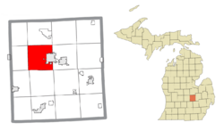
Location within Shiawassee County
|
|
| Country | United States |
| State | Michigan |
| County | Shiawassee |
| Organized | 1837 |
| Area | |
| • Total | 32.15 sq mi (83.3 km2) |
| • Land | 31.61 sq mi (81.9 km2) |
| • Water | 0.74 sq mi (1.9 km2) |
| Elevation | 768 ft (234 m) |
| Population
(2020)
|
|
| • Total | 4,765 |
| • Density | 148.21/sq mi (57.225/km2) |
| Time zone | UTC-5 (Eastern (EST)) |
| • Summer (DST) | UTC-4 (EDT) |
| ZIP code(s) | |
| Area code(s) | 989 |
| FIPS code | 26-61960 |
| GNIS feature ID | 1626876 |
Owosso Township, officially known as Owosso Charter Township, is a special type of local government called a charter township. It is located in Shiawassee County in the U.S. state of Michigan. In 2020, the population of the township was 4,765 people.
The township is next to the city of Owosso on its eastern side. However, even though they are close, Owosso Township and Owosso City are managed separately.
Contents
Communities in Owosso Township
Owosso Township is home to a few smaller communities. These are called "unincorporated communities" because they don't have their own separate local government like a city or village. They are part of the township's administration.
- Burton is an unincorporated community located along S. Baldwin Road. It was first called Mungerville in 1864. Later, its name was changed to Burton on May 3, 1878. The post office in Burton closed on January 31, 1936. This community is about 4.5 miles west of the city of Owosso.
- Five Points, sometimes called Five Points West or West Five Points, is another unincorporated community. It is located where M-21, Priest Road, and Smith Road meet.
- Smith Crossing is an unincorporated community found at Wilkinson and Smith roads. It is near where the Great Lakes Central Railroad tracks cross.
- Wolf Crossing is an unincorporated community that is partly in Owosso Township and partly in Rush Township.
History of Owosso Township
The first non-Native American settlers arrived in Owosso Township in 1835. These early settlers included Elias Comstock, Kilburn Bedell, and Lewis Findley. The very first building in the area, then known as Big Rapids, was built in 1836.
The township gets its name from an American Indian leader, Chief Wasso. Chief Wasso and his tribe lived in this area. They were later moved to a reservation by the U.S. government after a treaty in 1836. A post office opened in Big Rapids on November 4, 1838, and was named Owasso.
Shiawassee County was first set up as one large township on March 23, 1836. Owosso Township was then created from the northern part of Shiawassee Township on March 11, 1837. Over the years, other townships were formed from parts of Owosso Township, making it smaller.
By 1844, people started spelling the community's name as Owosso, which is how it is spelled today. In 1859, the community of Owosso became an official city.
Before 1864, the Detroit and Milwaukee Railroad built tracks through the western side of the township. A train station called Mungerville opened there. This Mungerville post office later changed its name to Burton in 1878. The Owasso post office officially changed its spelling to Owosso on June 8, 1875. The Burton post office closed on January 31, 1936.
Geography of Owosso Township
Owosso Township covers a total area of about 32.15 square miles. Most of this area, about 31.61 square miles, is land. The remaining part, about 0.74 square miles, is water. This means that about 2.30% of the township's total area is covered by water.
Population and People
Based on the census from 2000, there were 4,670 people living in Owosso Township. These people lived in 1,816 households, and 1,334 of these were families.
The population was spread out by age:
- About 24.8% of the people were under 18 years old.
- About 7.2% were between 18 and 24 years old.
- About 25.5% were between 25 and 44 years old.
- About 26.0% were between 45 and 64 years old.
- About 16.5% were 65 years old or older.
The average age of people in the township was 40 years. For every 100 females, there were about 98.7 males.
Transportation in Owosso Township
Highways
Two main state highways pass through or near Owosso Township:
- M-21
- M-52
Airport
 The Owosso Community Airport is located just east of the township in Caledonia Township.
See also
 In Spanish: Municipio de Owosso para niños


