Smithville-Sanders, Indiana facts for kids
Quick facts for kids
Smithville-Sanders, Indiana
|
|
|---|---|

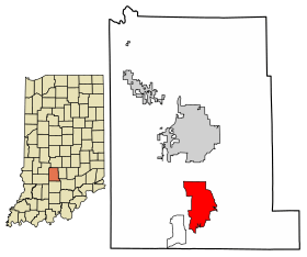
Location in Monroe County, Indiana
|
|
| Country | United States |
| State | Indiana |
| County | Monroe |
| Townships | Clear Creek, Perry |
| Area | |
| • Total | 10.72 sq mi (27.76 km2) |
| • Land | 10.72 sq mi (27.76 km2) |
| • Water | 0 sq mi (0.00 km2) |
| Elevation | 715 ft (218 m) |
| Population
(2020)
|
|
| • Total | 3,323 |
| • Density | 310.01/sq mi (119.70/km2) |
| Time zone | UTC-5 (Eastern (EST)) |
| • Summer (DST) | UTC-4 (EDT) |
| ZIP codes |
47458, 47401 (Bloomington)
|
| Area code(s) | 812 & 930 |
| GNIS feature ID | 2583471 |
| FIPS code | 18-70330 |
Smithville-Sanders is a special kind of community in Monroe County, Indiana, United States. It is called a census-designated place (CDP). This means it is an area that the government counts for population. However, it is not an official town or city. In 2020, about 3,323 people lived here. This area includes two smaller communities: Smithville and Sanders.
Exploring Smithville-Sanders
Smithville-Sanders is located in the southern part of Monroe County. The community of Smithville is in the northern-central area. It is found around where Smithville Road and Strain Ridge Road meet. Sanders is a short distance north, about half a mile away, on Fairfax Road. Most of this CDP is made up of rural and semi-suburban land. This land surrounds the two main villages.
Land and Water Features
According to the U.S. Census Bureau, Smithville-Sanders covers an area of about 10.72 square miles. All of this area is land. There is no water within its official boundaries.
To the south and east, the area is next to parts of Monroe Lake. This lake is a large reservoir built on Salt Creek. To the west, the area is bordered by Little Clear Creek. This creek is also part of the Salt Creek water system. Part of the western border is also next to Indiana State Road 37. This road goes north about 7 miles to Bloomington. It also goes south about 16 miles to Bedford.
Who Lives Here?
| Historical population | |||
|---|---|---|---|
| Census | Pop. | %± | |
| 2010 | 3,184 | — | |
| 2020 | 3,323 | 4.4% | |
| U.S. Decennial Census | |||
The population of Smithville-Sanders has grown over time. In 2010, the population was 3,184 people. By 2020, the number of people living here increased to 3,323. This information comes from the official United States census. The census helps us understand how many people live in different areas.
See also
 In Spanish: Smithville-Sanders (Indiana) para niños
 | James Van Der Zee |
 | Alma Thomas |
 | Ellis Wilson |
 | Margaret Taylor-Burroughs |

