
Snow Hill Island facts for kids

Snow Hill Island, January 1999
|
|

Snow Hill Island
Location in Antarctica
Location in Antarctica
|
|
| Geography | |
|---|---|
| Location | Antarctica |
| Coordinates | 64°28′S 57°12′W / 64.467°S 57.200°W |
| Archipelago | James Ross Island group |
| Length | 33 km (20.5 mi) |
| Width | 12 km (7.5 mi) |
| Administration | |
| Administered under the Antarctic Treaty System | |
| Demographics | |
| Population | uninhabited |
Snow Hill Island is an island in Antarctica. It is almost completely covered in snow. The island is about 33 kilometers (20 miles) long and 12 kilometers (7.5 miles) wide. It is located off the east coast of the Antarctic Peninsula.
Snow Hill Island is near James Ross Island and Seymour Island. A narrow waterway called Admiralty Sound separates it from James Ross Island. Picnic Passage separates it from Seymour Island. This island is part of a group of islands around Graham Land. Graham Land is the part of Antarctica closest to South America.
Contents
Exploring Snow Hill Island
The island was found on January 6, 1843. A British team led by James Clark Ross discovered it. Ross was not sure if it was connected to the mainland. He named it Snow Hill because its snow stood out. Nearby Seymour Island had bare ground, which was a big contrast.
In 1902, the Swedish Antarctic Expedition confirmed it was an island. This team was on a ship called Antarctic. Their leader was Otto Nordenskiöld. He and his team spent three winters there, from 1901 to 1903. They used Snow Hill Island as a base. From there, they explored other islands and the Nordenskjold Coast.
A Historic Building

The Swedish Expedition built a wooden hut in February 1902. This hut is also known as Nordenskiöld House. It is now a Historic Site or Monument (HSM 38). Argentina and the United Kingdom suggested this. The Antarctic Treaty Consultative Meeting agreed to protect it.
The Land of Snow Hill Island
Snow Hill Island has interesting land features. The Spath Peninsula is at the island's northeast end. It is about 6.5 kilometers (4 miles) long and has no ice. The northernmost point of the island is Cape Lázara. This cape was named by an Argentine ship in 1953–54. It honors Lieutenant Costa Lázara, an Argentine navy pilot. He died in a flying accident.


Haslum Crag is a large rock near the north coast. It is about 2 nautical miles (3.7 km) northeast of Station Nunatak. A nunatak is a rocky peak that sticks out of an ice sheet. Station Nunatak is about 150 meters (490 feet) tall. The Swedish Antarctic Expedition first saw these features. The Falkland Islands Dependencies Survey mapped them in 1952.
Nordenskiöld named Station Nunatak because it was close to their winter station. He called Haslum Crag "Basaltspitze." Later, the United Kingdom Antarctic Place-Names Committee changed its name. They wanted to avoid confusion. They named it Haslum Crag to honor H.J. Haslum. He was the second mate on the Antarctic ship.
The northeast coast has old sedimentary rocks. These rocks formed from layers of sand and mud over time. They contain many fossils. You can find fossils of ammonites, gastropods, and bivalves. These are ancient sea creatures. There are also many basalt dikes. These are walls of volcanic rock that push up through the older sedimentary rocks.
Day Nunatak and Dingle Nunatak are inside the island's main ice cap. The UK Antarctic Place-Names Committee named them in 1995. Day Nunatak honors Crispin Mark Jeremy Day. He worked for the British Antarctic Survey (BAS) for many years. Dingle Nunatak is named after Richard Vernon Dingle. He was a senior BAS geologist. Both men were part of a BAS team exploring the James Ross Island area.
Sanctuary Cliffs are rock cliffs at the north edge of the island's central ice cap. The Swedish Expedition first mapped them. They called them "Mittelnunatak." This name meant "middle nunatak." Later, it was decided that "cliffs" was a better word for them. The UK-APC gave them a new name, Sanctuary Cliffs. This name shows how the cliffs offer shelter from strong winds.
Important Bird Area
A special area at the southwest end of the island is very important for birds. It includes 263 hectares (650 acres) of sea ice next to the coast. This area is an Important Bird Area (IBA). BirdLife International has identified it as such.
This area is home to a large breeding colony of emperor penguins. About 4,000 pairs of emperor penguins live and raise their young here. It is one of only two such colonies on land in the Antarctic Peninsula region. The other colony is at the Dion Islands.
Images for kids
-
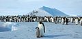
Snow Hill Island's colony of Emperor penguins, photographed in 2007

See also
 In Spanish: Isla Cerro Nevado para niños
