James Ross Island facts for kids

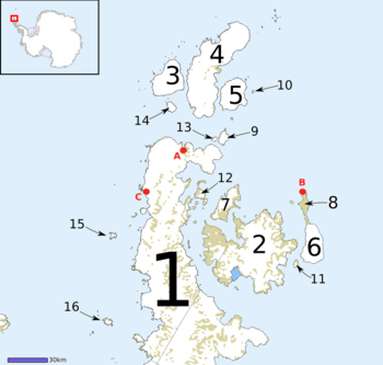
Map of Graham Land, showing James Ross Island (2)
|
|
|
James Ross Island (Antarctic Peninsula)
|
|
| Geography | |
|---|---|
| Location | Antarctica |
| Coordinates | 64°10′S 57°45′W / 64.167°S 57.750°W |
| Archipelago | James Ross Island group |
| Area | 2,598 km2 (1,003 sq mi) |
| Length | 64 km (39.8 mi) |
| Highest elevation | 1,630 m (5,350 ft) |
| Highest point | Mount Haddington |
| Administration | |
| Administered under the Antarctic Treaty System | |
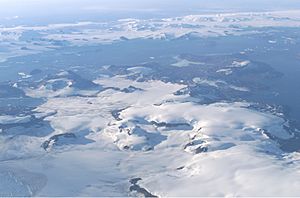
James Ross Island is a large island located near the Antarctic Peninsula. It sits off the southeast side of the peninsula. A channel called Prince Gustav Channel separates it from the mainland.
The island is quite big, stretching about 64 km (40 miles) from north to south. Its highest point is Mount Haddington, which is 1,630 metres (5,350 ft) tall.
In October 1903, the Swedish Antarctic Expedition explored and mapped the island. The expedition was led by Otto Nordenskiöld. He named the island after Sir James Clark Ross. Sir James Ross led a British expedition in 1842. His team discovered and mapped parts of the island's eastern side. The name "James Ross Island" helps avoid confusion with Ross Island in McMurdo Sound.
James Ross Island is part of a group of islands around the Graham Land area. This part of Antarctica is closer to South America than any other.
Until 1995, an ice shelf connected the island to the Antarctic mainland. When this ice shelf broke apart, the Prince Gustav Channel became open for ships for the first time.
The first Czech research station in Antarctica, called Mendel Polar Station, is located on James Ross Island.
Contents
Discovering Dinosaurs on James Ross Island
James Ross Island is a very special place for finding dinosaur fossils! It has two rock layers from the Upper Cretaceous period. These are the Santa Marta Formation and the Snow Hill Island Formation. These two layers are among only three places in all of Antarctica where dinosaur fossils have been found.
The First Antarctic Dinosaur
The very first dinosaur ever found in Antarctica was Antarctopelta oliveroi. This was a medium-sized ankylosaur, which is a type of armored dinosaur. Argentinian geologists Eduardo Olivero and Roberto Scasso discovered it in 1986. They found it on James Ross Island.
The fossil came from the Santa Marta Formation. This area is about 2 km (1.2 mi) south of Santa Marta Cove. Even though it was found in 1986, the dinosaur wasn't officially named until 2006.
More Dinosaur Discoveries
In December 2003, two American scientists found more dinosaur bones on the island. They were paleontologist Judd Case and geologist James Martin. They discovered parts of a theropod dinosaur. Theropods are meat-eating dinosaurs, like Tyrannosaurus rex.
This new dinosaur was nicknamed "Naze" because it was found on the Naze Peninsula. The remains included an upper jaw with teeth, and most of its lower legs and feet. The shape of its legs and feet suggests it was a fast runner. In 2019, this dinosaur was officially named Imperobator antarcticus. It was a large dinosaur, similar in size to Utahraptor. This was the second theropod dinosaur found in Antarctica. The first was Cryolophosaurus.
Other Dinosaurs Found Here
In 2008, Argentinian paleontologists Rodolfo Aníbal Coria and Juan José Moly found an ornithopod dinosaur. Ornithopods were plant-eating dinosaurs. In 2013, Coria named it Trinisaura santamartaensis.
Another important discovery happened in 2015. A dinosaur called an iguanodontid was named Morrosaurus antarcticus. This fossil was found in 2002 by Fernando Novas. The name "Morrosaurus" comes from the El Morro site on James Ross Island where it was found. The second part of its name, "antarcticus," refers to Antarctica.
Places Named on James Ross Island
Many places on James Ross Island have been given names by different exploration teams. Here are a few interesting ones:
Brandy Bay
Brandy Bay is a bay about 2 nautical miles (4 km) wide on the northwest coast. It was likely first seen by Otto Nordenskiöld in 1903. Later, in 1945, the Falkland Islands Dependencies Survey (FIDS) mapped it. The name came from a funny incident in 1952. A FIDS team was there, and they debated whether to use medicinal brandy to treat a dog bite!
Rohss Bay
Rohss Bay is a large bay, about 11 nautical miles (20 km) wide. It's on the southwest side of James Ross Island. The Swedish Antarctic Expedition discovered it. Nordenskjold named it after August and Wilhelm Rohss, who helped fund the expedition.
Sharp Valley
Sharp Valley is a small valley located about 1 mile (1.6 km) east-southeast of Stoneley Point. It was named in 1983 after Michael C. Sharp. He was a field assistant for the British Antarctic Survey (BAS) in the area.
Stoneley Point
Stoneley Point is a rocky point on the northwest coast of the island. It's about 4 nautical miles (7 km) west of Brandy Bay. It was named in 1952 after Robert Stoneley, a FIDS geologist at Hope Bay.
See also
 In Spanish: Isla James Ross para niños
 | Delilah Pierce |
 | Gordon Parks |
 | Augusta Savage |
 | Charles Ethan Porter |


