
Solidaridad Municipality facts for kids
Quick facts for kids
Playa del Carmen
Playa del Carmen
|
|||
|---|---|---|---|
| Solidaridad | |||

Welcome sign over Highway 307
|
|||
|
|||

Location of Solidaridad in Quintana Roo
|
|||

Playa del Carmen
Location in Mexico
|
|||
| Country | Mexico | ||
| State | Quintana Roo | ||
| Established | 28 July 1993 | ||
| Municipal seat | Playa del Carmen | ||
| Area | |||
| • Municipality | 2,278 km2 (880 sq mi) | ||
| Elevation | 10 m (30 ft) | ||
| Population
(2020 census)
|
|||
| • Municipality | 333,800 | ||
| • Density | 146.53/km2 (379.52/sq mi) | ||
| • Urban | 155,902 | ||
| Time zone | UTC−5 (Southeast (US Eastern)) | ||
| Area code(s) | 984 | ||
| INEGI Code | 23008 | ||
| Website | https://gobiernodesolidaridad.gob.mx | ||


Solidaridad is one of the eleven municipalities in the Mexican state of Quintana Roo. Its main town and government center is Playa del Carmen.
This area is also home to Xcaret, an ancient Maya archaeological site. It's a place where history and nature meet!
Contents
Discover Solidaridad's Location
Solidaridad is located in the beautiful state of Quintana Roo, Mexico. It shares borders with other municipalities. To the north, you'll find Benito Juárez and Lázaro Cárdenas. To the south, it borders Tulum.
A part of the Caribbean Sea, called the Cozumel Channel, separates Solidaridad from its neighbor, Cozumel, to the east. The municipality covers an area of about 2,278 square kilometers.
Explore Solidaridad's Landscape
Like most of the Yucatan Peninsula, Solidaridad is mostly flat. The land gently slopes towards the sea. Most of the area is less than 25 meters (about 82 feet) above sea level.
The ground here is made of limestone. This type of rock doesn't allow rivers or streams to form on the surface. Instead, water flows underground in hidden rivers. Sometimes, these underground rivers come to the surface in natural sinkholes called cenotes. Cenotes and lakes are the main water sources in Solidaridad.
Meet Solidaridad's Communities
Solidaridad is made up of several towns and villages. The largest and most well-known is Playa del Carmen, which is also the municipal seat. Here are some of the biggest communities:
| Name | Population (2010 census) |
|---|---|
| Playa del Carmen | 149,923 |
| Puerto Aventuras | 5,979 |
| Barceló Maya | 606 |
| Grand Palladium | 334 |
| Cárcel Pública | 314 |
| Iberostar | 242 |
| Felipe Carrillo Puerto | 176 |
| Punta Laguna | 138 |
| El Dorado | 131 |
| Hidalgo y Cortez | 128 |
| Grand Sirenis | 125 |
| Total municipality | 159,310 |
Solidaridad's History and Growth
Solidaridad is one of the newest municipalities in Mexico. It was officially created on July 28, 1993. This happened by a decision of the State Congress. Before this, the area was part of the municipality of Cozumel.
Later, on March 13, 2008, Solidaridad was divided again. A new municipality called Tulum was formed from its southern part. This change adjusted Solidaridad's land area and population.
| Historical population | ||
|---|---|---|
| Year | Pop. | ±% p.a. |
| 1995 | 28,747 | — |
| 2000 | 63,752 | +17.27% |
| 2005 | 135,512 | +16.28% |
| 2010 | 159,310 | +3.29% |
| Source: INEGI Instituto Nacional de Estadística y Geografía | ||
Understanding Solidaridad's Population
In 2010, Solidaridad had a population of 159,310 people. This number includes 83,468 men and 75,842 women. It's important to remember that the Tulum Municipality had already separated by this time.
Many people living in Solidaridad today have moved there from other parts of Mexico. Most come from the southeastern states. Also, about 12% of the people in Solidaridad are from other countries.
Images for kids
-
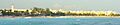
Playa del Carmen, the main town of Solidaridad
See also
 In Spanish: Municipio de Solidaridad para niños
