Somerville, Indiana facts for kids
Quick facts for kids
Somerville, Indiana
|
|
|---|---|

Somerville
|
|

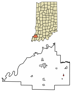
Location of Somerville in Gibson County, Indiana.
|
|
| Country | United States |
| State | Indiana |
| County | Gibson |
| Township | Barton |
| Area | |
| • Total | 0.36 sq mi (0.93 km2) |
| • Land | 0.36 sq mi (0.93 km2) |
| • Water | 0.00 sq mi (0.00 km2) |
| Elevation | 482 ft (147 m) |
| Population
(2020)
|
|
| • Total | 253 |
| • Density | 708.68/sq mi (273.37/km2) |
| Time zone | UTC-6 (Central (CST)) |
| • Summer (DST) | UTC-5 (CDT) |
| ZIP code |
47683
|
| Area code(s) | 812, 930 |
| FIPS code | 18-70542 |
| GNIS feature ID | 2397665 |
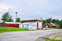
Somerville is a small town located in Gibson County, Indiana, in the United States. It is part of Barton Township. In 2010, the town had a population of 293 people. This made it the third-smallest community in Gibson County at that time.
Contents
History of Somerville
Somerville was first named Summittville when it was founded in 1853. Just one year later, in 1854, a post office opened in the town. At that time, the town's name was officially changed to Somerville.
Geography of Somerville
Somerville is located in the eastern part of Gibson County, Indiana. It lies northeast of a larger city called Evansville.
A main road, State Road 57, goes right through Somerville. This road connects the town to Oakland City to the northeast and Mackey to the southwest.
The town is quite small in size. According to the 2010 census, Somerville covers about 0.31 square miles (0.81 square kilometers). Almost all of this area is land, with only a very tiny amount being water.
Schools in Somerville
Students in Somerville and the eastern part of Gibson County attend schools managed by the East Gibson School Corporation. This school district currently runs four schools:
- Wood Memorial High School (for grades 9–12)
- Wood Memorial Junior High School (for grades 6–8)
- Wood Memorial Intermediate School (for grades 3–5)
- Wood Memorial Elementary School (for grades Kindergarten–2)
Population and People
| Historical population | |||
|---|---|---|---|
| Census | Pop. | %± | |
| 1930 | 273 | — | |
| 1940 | 373 | 36.6% | |
| 1950 | 353 | −5.4% | |
| 1960 | 317 | −10.2% | |
| 1970 | 313 | −1.3% | |
| 1980 | 340 | 8.6% | |
| 1990 | 223 | −34.4% | |
| 2000 | 312 | 39.9% | |
| 2010 | 293 | −6.1% | |
| 2020 | 253 | −13.7% | |
| U.S. Decennial Census | |||
A census is like a big count of all the people living in an area. It helps us understand how many people live somewhere and what they are like.
2010 Census Information
In 2010, the census showed that 293 people lived in Somerville. These people made up 110 households, and 78 of those were families.
The town had about 915 people per square mile. There were 121 housing units, which are places where people live, like houses or apartments.
Most of the people in Somerville were White (98.6%). A small number were African American (0.3%), Native American (0.3%), or from other backgrounds. About 2.4% of the population identified as Hispanic or Latino.
In the 110 households:
- About 32.7% had children under 18 living there.
- 56.4% were married couples living together.
- 9.1% had a female head of the household with no husband present.
- 5.5% had a male head of the household with no wife present.
- About 29.1% were not families, meaning individuals living alone or roommates.
The average household had about 2.66 people, and the average family had about 3.15 people.
The average age of people in Somerville was 36.9 years old.
- 28.3% of residents were under 18 years old.
- 7.6% were between 18 and 24 years old.
- 23.2% were between 25 and 44 years old.
- 24.5% were between 45 and 64 years old.
- 16.4% were 65 years old or older.
The town had a nearly equal number of males and females: 50.9% were male and 49.1% were female.
See also
 In Spanish: Somerville (Indiana) para niños
 | Valerie Thomas |
 | Frederick McKinley Jones |
 | George Edward Alcorn Jr. |
 | Thomas Mensah |

