
Sopchoppy River facts for kids
Quick facts for kids Sopchoppy River |
|
|---|---|
| Country | United States |
| State | Florida |
| Counties | Leon, Wakulla |
| District | NWFWMD |
| Physical characteristics | |
| Main source | East Branch Apalachicola National Forest, Leon County, Florida 30°18′29″N 84°34′38″W / 30.30806°N 84.57722°W |
| River mouth | Ochlockonee Bay Surf, Wakulla County, Florida 29°59′23″N 84°25′56″W / 29.98972°N 84.43222°W |
| Length | 46 mi (74 km) |
| Basin features | |
| Basin size | 330 sq mi (850 km2) |
| Tributaries |
|
The Sopchoppy River is a smaller river located in the Florida Big Bend area. It flows into the Ochlockonee River and is about 46 miles (74 km) long. Most of the river is in Wakulla County, with a small part of its East Branch reaching into Leon County.
Where is the Sopchoppy River?
The Sopchoppy River starts in the Apalachicola National Forest. It also flows through the Bradwell Bay Wilderness. You can find the town of Sopchoppy right along its banks. The river is an important part of the natural landscape in this part of Florida.
Exploring the River
If you love outdoor adventures, the Sopchoppy River is a great place to visit. There is a special canoe trail that is 15 miles (24 km) long. This trail is perfect for canoeing or kayaking. It runs from the Oak Park Cemetery Bridge all the way to US 319. It's a fun way to see the beautiful nature around the river.
Crossing the River
Many roads and bridges cross the Sopchoppy River as it winds through the landscape. These crossings help people travel around the area. Some of these bridges are in the town of Sopchoppy itself. They connect different parts of the community.
Images for kids
-
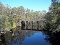
A bridge carrying County Road 375 over the Sopchoppy River.
-
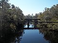
Another bridge, this one for County Road 22, crossing the Sopchoppy River.


