South Branch Penobscot River facts for kids
Quick facts for kids South Branch Penobscot River |
|
|---|---|
| Country | United States |
| Physical characteristics | |
| Main source | Maine 1,860 feet (570 m) |
| River mouth | Seboomook Lake 1,070 feet (330 m) 45°53′53″N 69°57′58″W / 45.898°N 69.966°W |
| Length | 39 miles (63 km) |
| Basin features | |
| Progression | West Branch – Penobscot River |
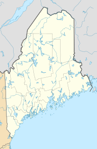
The South Branch Penobscot River is a river located in Somerset County, Maine, in the United States. It's one of the important rivers that help form the larger Penobscot River system.
This river starts from its source, Penobscot Lake. The northern part of this lake is only about 1,000 feet (300 meters) away from the border between Canada and the United States. This area is known as Sandy Bay. The border here follows a natural high point in the land. This high point separates the areas where water flows into the Penobscot River from where it flows into the Monument River, which eventually reaches the Saint Lawrence River.
The South Branch Penobscot River flows for about 39 miles (63 kilometers) towards the northeast. It passes through a place called Canada Falls Lake. The river then joins with the North Branch of the Penobscot River in Seboomook Lake. When these two rivers meet, they form the West Branch Penobscot River. The West Branch then flows east out of Seboomook Lake.
Contents
Canada Falls Lake: A Key Part of the River
| Canada Falls Lake | |
|---|---|
| Location | Somerset County, Maine |
| Coordinates | 45°49′N 70°03′W / 45.817°N 70.050°W |
| Basin countries | United States |
| Max. length | 6 mi (9.7 km) |
| Surface area | 2,305 acres (933 ha) |
| Max. depth | 24 feet (7.3 m) |
| Water volume | 17,841 acre⋅ft (22,007,000 m3) |
| Surface elevation | 1,237 ft (377 m) |
Canada Falls Lake is an important lake along the South Branch Penobscot River. It was created by a dam built in the early 1900s. This dam is located about 5 miles (8 kilometers) upstream from where the South Branch meets the North Branch of the Penobscot River.
How Canada Falls Lake Was Formed
The dam caused the river to widen and deepen, creating the lake. The lake covers parts of the South Branch Penobscot River and also extends into nearby areas. It floods the river westward into Alder Brook Township and a smaller stream called Alder Brook southward into Soldiertown Township.
Lake Depth and Water Levels
Most of Canada Falls Lake is not very deep, usually less than 15 feet (4.6 meters). When the lake is completely full, it has the largest surface area of any lake on the South Branch Penobscot River. However, the water level in the lake often drops by late summer. It usually stays low until the snow melts the following spring, which fills it up again.
Wildlife in and Around the Lake
Brook trout are a type of fish that live in this area. They lay their eggs (spawn) in the river upstream from the lake and in smaller streams that flow into the lake. These smaller streams include Hale Brook, Mullen Brook, and Cunningham Brook. During the warmer months, these trout find cooler spots in the main river channel that runs through the lake. These cool spots are often fed by natural springs.
 | Kyle Baker |
 | Joseph Yoakum |
 | Laura Wheeler Waring |
 | Henry Ossawa Tanner |


