South Branch Rahway River facts for kids
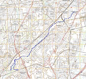
The South Branch Rahway River is a river in New Jersey. It flows north through a town called Woodbridge Township, New Jersey. Eventually, it joins the main Rahway River in Rahway, New Jersey. This meeting point is about 4.5 miles away from a waterway called the Arthur Kill. The river begins in a lake at Roosevelt Park in Edison, New Jersey.
Contents
About the South Branch Rahway River
The South Branch Rahway River is an important waterway. It helps carry water away from a large area. This area includes parts of Rahway, Edison, Woodbridge, and Metuchen. The river flows through many developed towns.
Where Does the River Start and End?
The journey of the South Branch Rahway River begins in Edison, New Jersey. It starts as water flowing from a lake in Roosevelt Park. From there, it travels north. It passes through Woodbridge Township. Finally, it meets the larger Rahway River. This happens in the town of Rahway. The Rahway River then flows into the Arthur Kill.
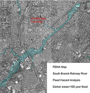
Why Does the River Flood?
The South Branch Rahway River often experiences flooding. This can happen for two main reasons. These are called tidal flooding and fluvial flooding. Understanding these types helps explain why the river overflows.
Types of Flooding: Tidal and Fluvial
- Tidal flooding: This happens when water from the ocean or a bay pushes up the river. The Rahway River is close to the Arthur Kill, which is connected to the ocean. When there are big coastal storms, ocean water can push far up the Rahway River. This causes water to flow backward into the South Branch. This backflow can reach as far as the St. Georges Bridge in Woodbridge.
- Fluvial flooding: This type of flooding happens when the river itself overflows. It's caused by too much rain or water flowing into the river. Experts believe this is the main reason for flooding in the South Branch.
How Urbanization Affects Flooding
The South Branch Rahway River has a "drainage area" of about 11.6 square miles. This is the land where all the rainwater flows into the river. Much of this area is "intensely developed." This means there are many buildings, roads, and parking lots. These are called "impervious surfaces" because water cannot soak into them.
When it rains, water quickly runs off these surfaces. It rushes into the river instead of soaking into the ground. This makes the river rise very fast, causing "flashy" floods. Also, the river's path has some problems. It has a "U" shape turn and six bridges close together. These act like blockages, making it hard for water to flow out quickly. This also makes flooding worse.
 | Claudette Colvin |
 | Myrlie Evers-Williams |
 | Alberta Odell Jones |


