South Greensburg, Pennsylvania facts for kids
Quick facts for kids
South Greensburg, Pennsylvania
|
|
|---|---|
|
Borough
|
|

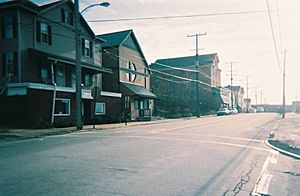
The borough's business district (Broad Street)
|
|

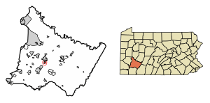
Location of South Greensburg in Westmoreland County, Pennsylvania.
|
|
| Country | United States |
| State | Pennsylvania |
| County | Westmoreland |
| Settled | 1780 |
| Incorporated | 1891 |
| Government | |
| • Type | Borough Council |
| Area | |
| • Total | 0.71 sq mi (1.83 km2) |
| • Land | 0.71 sq mi (1.83 km2) |
| • Water | 0.00 sq mi (0.00 km2) |
| Elevation | 1,073 ft (327 m) |
| Population
(2010)
|
|
| • Total | 2,117 |
| • Estimate
(2019)
|
1,996 |
| • Density | 2,823.20/sq mi (1,090.18/km2) |
| Time zone | UTC-5 (Eastern (EST)) |
| • Summer (DST) | UTC-4 (EDT) |
| Zip code |
15601
|
| Area code(s) | 724 |
| FIPS code | 42-72192 |
South Greensburg is a small town, called a borough, located in Westmoreland County, Pennsylvania, United States. In 2010, about 2,117 people lived there.
Contents
Discovering South Greensburg's Past
Early Days and Rughtown
In 1780, a man named Michael Rugh bought a large piece of land, about 229 acres. He used this land as a farm. His son, Jacob Rugh, and then Jacob's son, Peter Rugh, later owned the land.
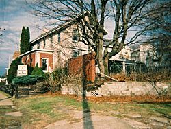
The Rugh family house still stands today at 1213 Broad Street. The building you see now was built around the time of the Civil War. But it was built on the foundation of a much older house. This area was known as Rughtown, even though it wasn't a real town yet.
From Farm to Hufftown
In the 1870s, a local business owner named George Franklin Huff bought 189 acres of the Rugh farm. In 1881, this land was sold to the Greensburg Coal and Coke Company. This company later became the Keystone Coal and Coke Company.
They built a mine and a brickyard along Broad Street. In 1888, fifty houses were built for the workers. During this time, the community was called Huff, Hufftown, or Pennsylvania Huff's Station.
Trolleys and Town Status
A trolley line was built in 1890 along Broad Street. It ran north into Greensburg. This trolley line was later bought by West Penn Railways. They ran trolley service until 1952.
In 1891, the community officially became a town. It was named the Borough of South Greensburg.
The Coal Strike of 1910-1911
South Greensburg was involved in a big event called the Westmoreland County Coal Strike of 1910–1911. This was a time when coal miners stopped working to ask for better conditions.
In July 1910, a group of striking miners were allowed to protest by the town's police chief, William B. Keltz. A fight happened between the marchers and security guards from the Jamison Coal and Coke Company. During the fight, a miner named Peter Gale was shot. The police chief tried to arrest the shooter, but instead, he was arrested by guards working for the company.
Walworth Valves: A Major Employer
For almost 100 years, the biggest employer in South Greensburg was Walworth Valves. This factory started in 1888 as the Kelly & Jones Company. George Franklin Huff was on their board of directors.
The Walworth Company bought the factory in 1925. This factory was very large, covering about 31 acres. At its busiest, it had 1500 employees. The factory closed in 1980 and was later torn down. Today, the area has an office building and other businesses.
South Greensburg's Location
South Greensburg is located at coordinates 40°16′38″N 79°32′55″W.
The borough covers a total area of 0.7 square miles (1.9 square kilometers). All of this area is land.
Population and People
South Greensburg has seen its population change over the years.
| Historical population | |||
|---|---|---|---|
| Census | Pop. | %± | |
| 1900 | 700 | — | |
| 1910 | 1,748 | 149.7% | |
| 1920 | 2,188 | 25.2% | |
| 1930 | 2,520 | 15.2% | |
| 1940 | 2,616 | 3.8% | |
| 1950 | 2,980 | 13.9% | |
| 1960 | 3,058 | 2.6% | |
| 1970 | 3,288 | 7.5% | |
| 1980 | 2,605 | −20.8% | |
| 1990 | 2,293 | −12.0% | |
| 2000 | 2,280 | −0.6% | |
| 2010 | 2,117 | −7.1% | |
| 2019 (est.) | 1,996 | −5.7% | |
| Sources: | |||
In 2000, there were 2,280 people living in the borough. There were 1,048 households, and 630 families. Most of the people were White (98.25%).
About 22.7% of households had children under 18 living with them. The average household had 2.17 people. The average family had 2.83 people.
The population was spread out by age. About 18.1% were under 18. About 21.5% were 65 years or older. The average age was 43 years.
The median income for a household in the borough was $32,540. For a family, it was $47,607. About 5.1% of the population lived below the poverty line.
See also
 In Spanish: South Greensburg (Pensilvania) para niños
 | Toni Morrison |
 | Barack Obama |
 | Martin Luther King Jr. |
 | Ralph Bunche |


