South Plains, Texas facts for kids
Quick facts for kids
South Plains, Texas
|
|
|---|---|

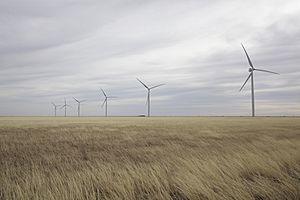
Wind farm near South Plains
|
|
| Country | United States |
| State | Texas |
| County | Floyd |
| Elevation | 3,215 ft (980 m) |
| Time zone | UTC-6 (Central (CST)) |
| • Summer (DST) | UTC-5 (CDT) |
| ZIP codes |
79258
|
South Plains is a small place in northern Floyd County, Texas, in the United States. It is called an "unincorporated community." This means it's a group of homes and businesses that isn't officially a city or town with its own local government.
South Plains is located along State Highway 207. It is just north of Floydada, which is the main town in Floyd County. The area sits at an elevation of 3,215 feet (980 meters) above sea level. Even though it's not a city, South Plains has its own post office with the ZIP code 79258.
Just north of South Plains, Quitaque Creek flows by. This creek has carved out a deep valley, called a gorge, in the Caprock escarpment. An escarpment is a long, steep slope or cliff. This gorge is about three miles east of the community.
History of South Plains
When South Plains Began
The community of South Plains started with a post office in 1909. At first, it was located a few miles away from where it is now. The post office moved two times before settling in its current spot in 1927. This final location was along the Fort Worth and Denver Railway, a train line that helped connect the area.
Growth and Challenges in the 1920s
South Plains grew quite a bit in the 1920s. During this time, a school was built, and new businesses opened up. However, the community faced a big challenge when the Great Depression began. The Great Depression was a time in the 1930s when many people lost their jobs and money. This difficult period caused the number of people living in South Plains to decrease.
 | John T. Biggers |
 | Thomas Blackshear |
 | Mark Bradford |
 | Beverly Buchanan |


