South Taft, California facts for kids
Quick facts for kids
South Taft
|
|
|---|---|

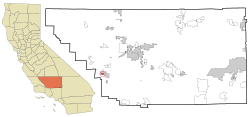
Location in Kern County and the state of California
|
|
| Country | |
| State | |
| County | Kern |
| Area | |
| • Total | 1.076 sq mi (2.787 km2) |
| • Land | 1.076 sq mi (2.787 km2) |
| • Water | 0 sq mi (0 km2) |
| Elevation | 1,017 ft (310 m) |
| Population
(2010)
|
|
| • Total | 2,169 |
| • Density | 2,015.8/sq mi (778.3/km2) |
| Time zone | UTC-8 (PST) |
| • Summer (DST) | UTC-7 (PDT) |
| ZIP code |
93268
|
| Area code(s) | 661 |
| FIPS code | 06-73388 |
| GNIS feature ID | 1661482 |
South Taft is a special kind of community in Kern County, California, United States. It's called a census-designated place (CDP). This means it's a place that the government counts for population, but it's not officially a city or town with its own local government.
South Taft is located about 0.5 miles (0.8 km) south of the city of Taft. It sits at an elevation of about 1,017 feet (310 meters) above sea level. In 2010, the population of South Taft was 2,169 people. This was an increase from 1,898 people counted in the year 2000.
Contents
Geography of South Taft
South Taft is found at specific geographic coordinates: 35°08′05″N 119°27′22″W. These numbers help pinpoint its exact location on a map.
The United States Census Bureau reports that South Taft covers a total area of about 1.1 square miles (2.8 square kilometers). All of this area is land, meaning there are no large bodies of water within its boundaries.
Who Lives in South Taft?
This section looks at the people who live in South Taft, based on information from government counts.
Population in 2010
The 2010 census showed that 2,169 people lived in South Taft. This means there were about 2,015 people per square mile (778 people per square kilometer).
Most people, about 64.7%, identified as White. About 27.5% were from other racial backgrounds. People of Hispanic or Latino origin made up 42.9% of the population.
Most residents, about 93.5%, lived in regular homes. The remaining 6.5% lived in group settings, like dorms, but not in institutions.
There were 606 households in South Taft. Nearly half of these, 48.3%, had children under 18 living there. About 41.4% were married couples. Other households included single parents or people living alone. The average household had about 3.35 people.
The age of people in South Taft varied. About 33.7% were under 18 years old. About 12.7% were between 18 and 24. People aged 25 to 44 made up 26.1% of the population. The median age was 27.1 years. This means half the population was younger than 27.1, and half was older.
There were 733 housing units available. About 44.6% of homes were owned by the people living in them. The other 55.4% were rented.
Population in 2000
In the 2000 census, South Taft had a population of 1,898 people. The population density was about 1,766 people per square mile (682 people per square kilometer).
About 79.14% of residents identified as White. About 13.96% were from other racial groups. People of Hispanic or Latino origin made up 25.66% of the population.
There were 629 households. About 41.0% of these households had children under 18. The average household size was 3.02 people.
The median age in 2000 was 29 years. About 35.1% of the population was under 18. About 9.4% were 65 or older.
The median income for a household was $20,921 per year. The median income for a family was $23,317. The average income per person was $9,929. About 39.5% of the population lived below the poverty line. This included 61.7% of children under 18.
See also
 In Spanish: South Taft para niños
 | Leon Lynch |
 | Milton P. Webster |
 | Ferdinand Smith |


