Southeast Piscataquis, Maine facts for kids
Quick facts for kids
Southeast Piscataquis, Maine
|
|
|---|---|

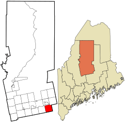
Location in Piscataquis County and the state of Maine.
|
|
| Country | United States |
| State | Maine |
| County | Piscataquis |
| Area | |
| • Total | 38.1 sq mi (98.7 km2) |
| • Land | 36.3 sq mi (93.9 km2) |
| • Water | 1.8 sq mi (4.8 km2) |
| Elevation | 302 ft (92 m) |
| Population
(2020)
|
|
| • Total | 487 |
| • Density | 12.782/sq mi (4.934/km2) |
| Time zone | UTC-5 (Eastern (EST)) |
| • Summer (DST) | UTC-4 (EDT) |
| ZIP code |
04463
|
| Area code(s) | 207 |
| FIPS code | 23-70655 |
| GNIS feature ID | 582734 |
| Top - 0-9 A B C D E F G H I J K L M N O P Q R S T U V W X Y Z |
Southeast Piscataquis is an area in Piscataquis County, Maine, United States. It is called an "unorganized territory." This means it does not have its own local government like a town or city. Instead, it is managed by the county or state.
The area includes Orneville Township and, since 2019, Atkinson Township. In 2020, about 487 people lived here.
About the Area
Southeast Piscataquis is located in the state of Maine. It is part of Piscataquis County. The area is known for its natural beauty.
Land and Water
The United States Census Bureau says that Southeast Piscataquis covers about 77.1 square miles (199.8 square kilometers). Most of this area, about 75.1 square miles (194.5 square kilometers), is land. The rest, about 2.1 square miles (5.4 square kilometers), is water. This means rivers, lakes, or ponds make up about 2.7% of the total area.
Population Changes
The number of people living in Southeast Piscataquis has grown quite a bit. Between 2010 and 2020, the population almost doubled.
Why the Population Grew
A big reason for this growth was that Atkinson became part of Southeast Piscataquis in 2019. Atkinson had 326 people in 2010. When it joined, those people became part of Southeast Piscataquis's population.
| Historical population | |||
|---|---|---|---|
| Census | Pop. | %± | |
| 1970 | 156 | — | |
| 1980 | 183 | 17.3% | |
| 1990 | 247 | 35.0% | |
| 2000 | 254 | 2.8% | |
| 2010 | 253 | −0.4% | |
| 2020 | 487 | 92.5% | |
| U.S. Decennial Census | |||
People in 2000
In 2000, there were 254 people living in this area. They lived in 101 households, and 73 of these were families.
- Most people (98.82%) were White.
- A small number were Native American (0.79%) or Pacific Islander (0.39%).
- About 0.39% of the population identified as Hispanic or Latino.
Households and Families
- About 31.7% of households had children under 18 living with them.
- Most households (58.4%) were married couples.
- The average household had about 2.51 people.
- The average family had about 2.78 people.
Age Groups
The population was spread out across different age groups:
- 22.8% were under 18 years old.
- 7.1% were between 18 and 24.
- 26.0% were between 25 and 44.
- 33.1% were between 45 and 64.
- 11.0% were 65 years or older.
The average age was 41 years.
Income Information
In 2000, the average income for a household was $28,036 per year. For families, the average income was $33,958 per year. The average income for each person was $11,940.
About 15.9% of families and 27.4% of all people lived below the poverty line. This included 41.1% of those under 18 and 13.3% of those 65 or older.
See also
 In Spanish: Southeast Piscataquis para niños
 | James Van Der Zee |
 | Alma Thomas |
 | Ellis Wilson |
 | Margaret Taylor-Burroughs |

