Southport, Oregon facts for kids
Quick facts for kids
Southport, Oregon
|
|
|---|---|

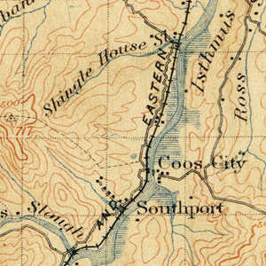
1896 USGS Topographic Map
|
|
| Country | United States |
| County | Coos County |
| Elevation | 30 ft (9 m) |
Southport was a small, unincorporated community located in Coos County, Oregon, United States. It was situated near Southport Creek, where the creek meets Isthmus Slough. This spot is about 6.5 miles (10.5 km) south of the city of Coos Bay. Southport was once a busy place, but today it is considered a ghost town. This means most people have moved away, and the town is no longer active.
Contents
Where Was Southport?
The former town of Southport is found on Southport Lane. This lane is just off US Highway 101. It is located south of the city of Coos Bay. The area is part of Coos County.
A Town Built on Coal
Southport began as a mining town.
The Southport Mine
- Between 1875 and 1877, a man named B. B. Jones opened a coal mine.
- He named it the Southport Mine.
- A small village quickly grew up right next to the mine.
- This village became the town of Southport.
A Company Town
Southport was a "company town." This means that one company owned most of the homes and businesses. The company that owned Southport was the Black Diamond Coal Mining Company. Their main office was in San Francisco, California. This company also owned other towns, like Nortonville, California and Black Diamond, Washington.
Life in Southport
- By 1882, about 100 people lived in Southport.
- The town had a general store where people could buy many different things.
- There was also a variety store and a hotel that included a saloon.
- A simple railroad, about 2,000 feet (610 meters) long, connected the mine to the slough. This helped move the coal.
No Post Office
Southport never had its own post office. Mail for Southport residents went to the post office in Coos City. Coos City was another town, now also a ghost town, located across Isthmus Slough from Southport.
What Happened to Southport?
The town of Southport began to decline in the mid-1880s.
Miners Move On
- In 1885, the Black Diamond Coal Mining Company opened a new, bigger mine.
- This new mine was in Black Diamond, Washington.
- Many miners from Southport and Nortonville moved to the new mine.
- This caused Southport's population to shrink.
The Mine Closes
- Around 1885, another mining company, the Newport Mine, leased the Southport Mine.
- However, they decided to keep the mine closed.
- With the mine closed and many miners gone, the town of Southport slowly faded away.
- Even though it was declining, Southport was still shown on a map from 1896.
- Eventually, it became the ghost town it is today.
 | May Edward Chinn |
 | Rebecca Cole |
 | Alexa Canady |
 | Dorothy Lavinia Brown |


