Spiceland, Indiana facts for kids
Quick facts for kids
Spiceland, Indiana
|
|
|---|---|

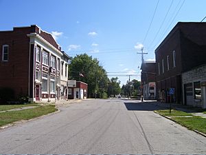
Spiceland Downtown
|
|

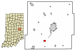
Location of Spiceland in Henry County, Indiana.
|
|
| Country | United States |
| State | Indiana |
| County | Henry |
| Township | Spiceland |
| Area | |
| • Total | 1.46 sq mi (3.78 km2) |
| • Land | 1.46 sq mi (3.78 km2) |
| • Water | 0.00 sq mi (0.00 km2) |
| Elevation | 1,066 ft (325 m) |
| Population
(2020)
|
|
| • Total | 958 |
| • Density | 657.06/sq mi (253.70/km2) |
| Time zone | UTC-5 (Eastern (EST)) |
| • Summer (DST) | UTC-4 (EDT) |
| ZIP code |
47385
|
| Area code(s) | 765 |
| FIPS code | 18-72008 |
| GNIS feature ID | 2397672 |
| Website | http://www.spicelandtown.org |
Spiceland is a small town located in Henry County, Indiana, in the United States. It is part of Spiceland Township. In 2020, about 958 people lived there.
Contents
History of Spiceland
Spiceland was officially planned and mapped out in 1850. This process is called "platting." The town got its name because of the many spice bushes that grew near where the town was first built. At first, the area was mostly used for farming spices.
Geography of Spiceland
Spiceland is a small town. According to information from 2010, the town covers an area of about 0.5 square miles (1.3 square kilometers). All of this area is land, with no large bodies of water.
People of Spiceland
| Historical population | |||
|---|---|---|---|
| Census | Pop. | %± | |
| 1870 | 370 | — | |
| 1880 | 527 | 42.4% | |
| 1890 | 637 | 20.9% | |
| 1900 | 590 | −7.4% | |
| 1910 | 622 | 5.4% | |
| 1920 | 632 | 1.6% | |
| 1930 | 722 | 14.2% | |
| 1940 | 645 | −10.7% | |
| 1950 | 739 | 14.6% | |
| 1960 | 863 | 16.8% | |
| 1970 | 957 | 10.9% | |
| 1980 | 940 | −1.8% | |
| 1990 | 757 | −19.5% | |
| 2000 | 807 | 6.6% | |
| 2010 | 890 | 10.3% | |
| 2020 | 958 | 7.6% | |
| U.S. Decennial Census | |||
This section tells you about the people who live in Spiceland. It includes details like how many people live there and their ages.
What is a Census?
A census is like a big count of all the people living in a place. It happens every ten years in the United States. This helps us understand how many people live in towns and cities.
Spiceland's Population in 2010
In 2010, the census showed that 890 people lived in Spiceland. These people lived in 353 households, and 256 of these were families. A household is a group of people living together in one home.
The town had about 1780 people per square mile (687 people per square kilometer). Most of the people living in Spiceland were White (98.5%). A small number of people were from other backgrounds.
About 34.8% of the households had children under 18 living with them. Many households (58.4%) were married couples. About 24.9% of all households were made up of just one person.
The average age of people in Spiceland was 39.5 years old. About 26.9% of the residents were under 18. Also, 16.5% of the people were 65 years old or older. The town had a nearly equal number of males (49.0%) and females (51.0%).
Education in Spiceland
Spiceland has a public library for its residents. It is called the Spiceland Town-Township Public Library. This library lends out books and other materials to people in the town.
See also
 In Spanish: Spiceland (Indiana) para niños
 | Sharif Bey |
 | Hale Woodruff |
 | Richmond Barthé |
 | Purvis Young |


