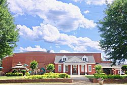
Spindale, North Carolina facts for kids
Quick facts for kids
Spindale, North Carolina
|
|
|---|---|

Spindale House
|
|
| Nickname(s):
The Dale
|
|
| Motto(s):
Small Town Friendly
|
|

Location of Spindale, North Carolina
|
|
| Country | United States |
| State | North Carolina |
| County | Rutherford |
| Area | |
| • Total | 5.41 sq mi (14.01 km2) |
| • Land | 5.41 sq mi (14.01 km2) |
| • Water | 0.00 sq mi (0.00 km2) |
| Elevation | 994 ft (303 m) |
| Population
(2020)
|
|
| • Total | 4,225 |
| • Density | 781.25/sq mi (301.66/km2) |
| Time zone | UTC-5 (Eastern (EST)) |
| • Summer (DST) | UTC-4 (EDT) |
| ZIP code |
28160
|
| Area code(s) | 828 |
| FIPS code | 37-63880 |
| GNIS feature ID | 2407383 |
Spindale is a town located in Rutherford County, North Carolina, in the United States. In 2020, about 4,225 people lived there.
Contents
A Look Back at Spindale's History
From Mill Town to Modern Day
Spindale started as a "mill town." This means its main purpose was to support textile mills, which are factories that make cloth. The first mill, Spencer Mills, opened in 1916. Later, Stonecutter Mills, started in 1920, became very important. However, this last mill closed in 1999.
The town of Spindale officially became a town on August 21, 1923. In 1939, the state government passed a law that almost doubled the size of Spindale.
Important Places and Buildings
In 1926, the famous Spindale House opened. It was a gift to the town from the Tanner family. This building served as a place for the community to gather and have fun.
Another important place was Greene's Grocery Store, which also opened in 1926. It was a classic part of the mill village. For over 50 years, it was the most popular store for many mill families. It even offered home delivery and let people buy things on credit.
Community Life and Entertainment
The first churches in Spindale were First Baptist (1917), Methodist (1919), Presbyterian (1922), and Spencer Baptist (1926).
In 1930, the Carolina Theater opened on Main Street. It was a movie theater that could hold 360 people. It stayed open until 1961.
The town also had its own newspaper, The Spindale Sun, which started in 1941.
Where is Spindale Located?
Spindale is found along U.S. Route 221A. This road connects it to Forest City to the southeast and Rutherfordton to the west. Another road, U.S. Route 74A, goes through the southern part of the town.
The United States Census Bureau says that Spindale covers about 5.5 square miles (14.01 square kilometers) of land. There is no water area within the town limits.
Who Lives in Spindale?
| Historical population | |||
|---|---|---|---|
| Census | Pop. | %± | |
| 1930 | 3,066 | — | |
| 1940 | 3,952 | 28.9% | |
| 1950 | 3,891 | −1.5% | |
| 1960 | 4,082 | 4.9% | |
| 1970 | 3,848 | −5.7% | |
| 1980 | 4,246 | 10.3% | |
| 1990 | 4,040 | −4.9% | |
| 2000 | 4,022 | −0.4% | |
| 2010 | 4,321 | 7.4% | |
| 2020 | 4,225 | −2.2% | |
| U.S. Decennial Census | |||
Spindale's Population in 2020
The 2020 United States census counted 4,225 people living in Spindale. There were 1,564 households and 938 families.
| Group | Number | Percentage |
|---|---|---|
| White (not Hispanic) | 2,758 | 65.3% |
| Black or African American (not Hispanic) | 1,004 | 23.8% |
| Native American | 26 | 0.6% |
| Asian | 29 | 0.7% |
| Pacific Islander | 6 | 0.1% |
| Other/Mixed | 250 | 5.9% |
| Hispanic or Latino | 152 | 3.6% |
Education in Spindale
Spindale is home to Isothermal Community College. This is a two-year college that is part of the North Carolina Community College system. It gets its name from being located in the "thermal belt," an area with milder temperatures.
Media and Radio
WNCW is a special radio station located at Isothermal Community College. It's a non-commercial station, meaning it doesn't play ads. It's also connected with NPR. You can listen to WNCW at 88.7 MHz. The station plays a wide variety of music. Because it's also available online, people listen to it from all over the world, not just in its local area.
Famous People from Spindale
- Bobby F. England – He was a member of the North Carolina General Assembly, which is the state's law-making body.
See also

- In Spanish: Spindale para niños
 | Frances Mary Albrier |
 | Whitney Young |
 | Muhammad Ali |

