Spon Lane Locks Branch facts for kids
Quick facts for kids Spon Lane Locks Branch |
|
|---|---|

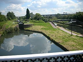
Spon Lane bottom lock at the start of the approach to the Old Main Line, with the New Main Line to the right
|
|
| Specifications | |
| Status | Open |
| Navigation authority | Canal and River Trust |
| History | |
| Date completed | 1769 |
The Spon Lane Locks Branch is a short part of the BCN Main Line canal in Oldbury, England. It's like a special "sliproad" that connects two main canal lines. This branch runs for about 800 yards (or 730 meters) from Spon Lane Junction to Bromford Junction.
Contents
What is the Spon Lane Locks Branch?
This canal branch helps boats move between the Old BCN Main Line and the New BCN Main Line. These two main lines cross each other at a place called the Stewart Aqueduct. The Spon Lane Locks Branch goes west from Spon Lane Junction, which is under the M5 motorway. Along its path, you'll find three special locks called the Spon Lane Locks.
How Old is the Spon Lane Locks Branch?
This branch was originally part of the Wednesbury branch of the Birmingham Canal. It first opened way back in 1769! This makes the locks on this branch some of the oldest working locks in the entire country. Imagine, they've been helping boats for over 250 years!
What is a Split Bridge?
At the top lock of Spon Lane, there's a very unusual bridge called a split bridge. This type of bridge was designed so that a horse pulling a boat could cross the canal without being unhooked from its rope. The bridge has two halves with a gap in the middle. The rope would simply pass through this gap. The split bridge you see there today is a modern version, rebuilt in 1986, but it shows how clever engineers were long ago.
Can You Walk Along the Canal?
Yes, there is a path next to the canal called a towpath. You can walk along its entire length. However, it can be quite narrow and muddy, so it's not the best place for cycling. It's perfect for a quiet walk to explore a bit of history!
What is a Benchmark?
Near the Spon Lane bottom lock, you can find something called an Ordnance Survey rivet benchmark. This is a small metal marker that surveyors use to show a very exact height above sea level. This particular benchmark tells us the spot is about 140.43 meters (or 460.7 feet) above sea level at Newlyn. There's another similar benchmark further along this branch, at Smethwick Middle Lock. These markers are important for making accurate maps.
 | Leon Lynch |
 | Milton P. Webster |
 | Ferdinand Smith |

