Spring Creek (Little Kanawha River tributary) facts for kids
Quick facts for kids Spring Creek |
|
|---|---|

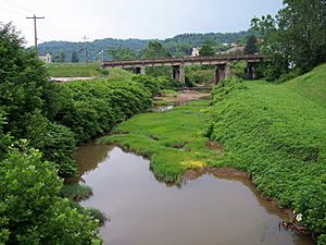
Spring Creek in Spencer in 2006
|
|

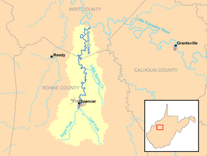
Spring Creek and its watershed
|
|
| Country | United States |
| State | West Virginia |
| Counties | Roane, Wirt |
| Physical characteristics | |
| Main source | Left Fork Spring Creek near Clover, southeast of Spencer, Roane County 1,033 ft (315 m) 38°42′56″N 81°17′08″W / 38.7156466°N 81.2856741°W |
| 2nd source | Right Fork Spring Creek near Speed, south of Spencer, Roane County 1,041 ft (317 m) 38°43′43″N 81°24′14″W / 38.728701°N 81.40401°W |
| River mouth | Little Kanawha River Sanoma, Wirt County 620 ft (190 m) 38°57′49″N 81°19′24″W / 38.9636934°N 81.3234521°W |
| Length | 25.3 mi (40.7 km) |
| Basin features | |
| Basin size | 89 sq mi (230 km2) |
| Tributaries |
|
Spring Creek is a river in western West Virginia, United States. It flows into the Little Kanawha River. This means Spring Creek is a tributary (a smaller river that flows into a larger one).
The water from Spring Creek eventually joins the Ohio River and then the mighty Mississippi River. So, Spring Creek is part of the huge watershed (an area of land where all the water drains into a common river) of the Mississippi River. It drains about 89 square miles (230 square kilometers) of land. The river is about 25.3 miles (40.7 kilometers) long. If you include its longest branch, the Left Fork, it's about 33.3 miles (53.6 kilometers) long.
Contents
Where Spring Creek Begins
Spring Creek starts just south of Spencer. Spencer is a city in northern Roane County. The creek forms when two smaller streams meet. These streams are called the Left Fork Spring Creek and the Right Fork Spring Creek.
Left Fork Spring Creek
The Left Fork Spring Creek is about 8 miles (13 kilometers) long. It begins near a community called Clover. From there, it flows towards the northwest. A road called West Virginia Route 36 runs alongside it for most of its path.
Right Fork Spring Creek
The Right Fork Spring Creek is a bit shorter, about 7.8 miles (12.6 kilometers) long. It starts near a place called Speed. This fork flows north. U.S. Route 119 follows it for most of its journey.
Spring Creek's Journey
After the Left and Right Forks join, Spring Creek flows north. It passes through Spencer and then enters southeastern Wirt County. Finally, it flows into the Little Kanawha River. This happens at a community called Sanoma. Sanoma is about 8 miles (13 kilometers) southeast of Elizabeth.
Little Spring Creek
There's another smaller stream called Little Spring Creek. It's about 7 miles (11 kilometers) long. This stream is a tributary of Spring Creek itself. It flows into Spring Creek in northeastern Roane County.
Charles Mill Lake
About 2 miles (3.2 kilometers) southeast of Spencer, you'll find Charles Mill Lake. This lake was created by building a dam on Charles Fork. Charles Fork is a stream that flows into the Left Fork Spring Creek. The city of Spencer owns this lake. It was built in 1974.
Charles Mill Lake is a popular spot for outdoor activities. People enjoy boating, fishing, hiking, biking, and camping there. It's a great place to spend time outdoors.
What Grows Around Spring Creek
The land around Spring Creek is mostly covered in forests. About 79.5% of the area is forested. Most of these trees are deciduous, which means they lose their leaves in the fall. The remaining land, about 18.7%, is used for farms and pastures where animals graze.
 | Jessica Watkins |
 | Robert Henry Lawrence Jr. |
 | Mae Jemison |
 | Sian Proctor |
 | Guion Bluford |

