Spurr Township, Michigan facts for kids
Quick facts for kids
Spurr Township, Michigan
|
|
|---|---|

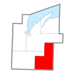
Location within Baraga County (red) and the administered CDP of Three Lakes (pink)
|
|
| Country | |
| State | |
| County | |
| Area | |
| • Total | 159.0 sq mi (411.9 km2) |
| • Land | 150.8 sq mi (390.6 km2) |
| • Water | 8.2 sq mi (21.3 km2) |
| Elevation | 1,745 ft (532 m) |
| Population
(2020)
|
|
| • Total | 262 |
| • Density | 2/sq mi (0.7/km2) |
| Time zone | UTC-5 (Eastern (EST)) |
| • Summer (DST) | UTC-4 (EDT) |
| FIPS code | 26-76000 |
| GNIS feature ID | 1627115 |
Spurr Township is a special kind of local government area called a civil township. It is located in Baraga County, which is part of the U.S. state of Michigan. In 2020, about 262 people lived there.
Contents
A Look Back: Spurr Township's History
Spurr Township was first set up when it was part of Houghton County. Later, in 1875, it became one of the first four townships in Baraga County. This happened when Baraga County was created from parts of Houghton County.
How Spurr Township Got Its Name
The township is named after "Spurr Mountain." This mountain was home to an iron ore mine. Iron ore is a rock from which we can get iron, a very useful metal. The mine was first run by the "Spurr Mountain Mining Company," which started in 1872. The mine stopped working in 1878 but opened again in 1881. A new company, the "Spurr Iron Mining Company," took over.
The Spurr Mountain Post Office
A post office called "Spurr Mountain" opened on December 30, 1874. It closed for a while on December 15, 1887. But it reopened on June 4, 1890, and stayed open until June 30, 1896.
Exploring Spurr Township's Geography
Spurr Township covers a total area of about 411.9 square kilometers (or 159.0 square miles). Most of this area, about 390.6 square kilometers (150.8 square miles), is land. The rest, about 21.3 square kilometers (8.2 square miles), is water. This means that about 5.16% of the township is covered by water.
Communities Within Spurr Township
Spurr Township does not have any large cities or towns with their own governments. Instead, it has a few smaller places called unincorporated communities and historic spots. These are places where people live, but they are not officially organized as towns.
- Beaufort Lake: This is one of the unincorporated communities in the township.
- Nestoria: This community is about 14 miles east of Covington. You can find it along US 41 and M-28.
- The Story Behind the Name: Nestoria got its name from the Nestor Lumber Company. This company was working in the area when a railroad, the Duluth, South Shore and Atlantic Railway, built its tracks nearby in 1871. The train station near the lumber company was called "Nestoria."
- Nestoria's Post Office: A post office opened in Nestoria on May 11, 1887. It closed on April 30, 1892, but reopened on May 7, 1895. The post office finally closed for good on February 1, 1974.
- Imperial Heights: This community is located about a mile west of Michigamme. It is near the Spurr River and the western end of Lake Michigamme.
- Three Lakes: This is another unincorporated community in the township. It is also known as a census-designated place (CDP). This means the government counts it as a specific area for census information.
Population of Spurr Township
According to the 2020 census, the total number of people living in Spurr Township was 262.
See also
 In Spanish: Municipio de Spurr para niños
 | William L. Dawson |
 | W. E. B. Du Bois |
 | Harry Belafonte |


