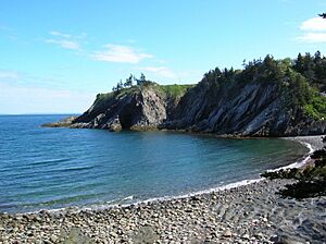
St. Marys Bay, Nova Scotia facts for kids
St. Marys Bay (also known as Baie Sainte-Marie in French) is a large bay located in southwestern Nova Scotia, Canada. It's surrounded by the areas of Clare and Digby. This beautiful bay is part of the traditional lands of the Mi'kmaq people, known as Kespukwitk in Miꞌkmaꞌki.
St. Marys Bay is a very important area for fishing. It's part of Federal Fishing District 34, which is the busiest lobster fishing zone in Canada. In one recent season, fishermen caught over 1,691 metric tonnes of lobster here, worth about $25 million! The bay is also famous for other seafood like haddock, herring, mackerel, clams, and scallops.
Early History: The Mi'kmaq People
The Mi'kmaq people have lived in and used the lands and waters around St. Marys Bay for a very long time, even before Europeans arrived. They call the bay Wagweiik. Places like Digby Neck (Oostitukum) and the mainland shore were important to them.
Evidence shows that the mouth of Salmon River was a traditional summer home for the Mi'kmaq. Many old tools and items have been found there, as well as in Meteghan and Church Point. Mi'kmaq names like Hectanooga and Mitihikan (Meteghan) are still used today. They also had a main settlement near River Allen, close to Cape Sainte-Marie, which was great for fishing and canoe travel.
The Mi'kmaq were skilled fishermen. They used a special system called a fishing weir to catch mackerel and herring. They taught this method to the new settlers, who continued to use it for many years. The Mi'kmaq also knew how to dry fish, a technique still used today. Besides fish, they gathered eels, seals, clams, sea urchins, berries, and medicinal plants from the coast.
When new settlers arrived in the 1760s and 1780s, the Mi'kmaq helped them survive the harsh winters along the coast. By the 1800s, most Mi'kmaq moved to the Bear River Reserve. However, they still returned to St. Marys Bay throughout the year for fishing, hunting, trading, and ceremonies.
The Geography of the Bay
St. Marys Bay is a smaller part of the larger Gulf of Maine. Its southeastern shore is the mainland of Nova Scotia. The northwestern shore is formed by a long, narrow strip of land called the Digby Neck, along with Long Island and Brier Island.
The bay divides two areas in Digby County. The Clare Municipal District, where both English and French are spoken, is on the mainland side. The Digby Municipal District includes the Digby Neck.
The waters around St. Marys Bay have shaped life here in many ways. The tides are incredibly high, sometimes rising and falling by as much as 16 meters (50 feet)! These strong tides create a special environment for many different plants and animals. When the tide goes out, large areas of the ocean floor are exposed, which is perfect for certain species.
The powerful tides also stir up the water, bringing food like plankton closer to the surface. This is why the nearby Bay of Fundy is famous for whale watching. Whales come here to feed easily.
In the past, shipbuilding was a big industry in the area. The high tides helped a lot. Shipbuilders could use dry docks to build large boats. When the tide came in, the finished ships could float away without needing to be moved. Fishing weirs also benefit from the tides. Fish swim into the weir at high tide. When the tide goes out, the fish are trapped, and fishermen can easily scoop them up.
Several communities are located along St. Marys Bay. These include Sandy Cove, Weymouth, Belliveaus Cove, Comeauville, Saulnierville, and Meteghan.
You can also visit public parks along the bay, such as Smugglers Cove Provincial Park in Meteghan, Mavilette Beach near Cape St. Marys, and Savary Picnic Park in Plympton.
Understanding Indigenous Fishing Rights
In 1752, the Sipekne’katik First Nation signed a Peace and Friendship Treaty with the King's representatives. This treaty confirmed many rights for the Sipekne’katik people, including the freedom to hunt and fish.
In the fall of 2020, the Sipekne’katik First Nation began their own self-managed fishery in St. Marys Bay. They were exercising their treaty right to fish for a "moderate livelihood," which means fishing to support their families and communities. This right was confirmed by a Supreme Court decision in 1999.
However, this led to disagreements with some non-Indigenous fishermen. These fishermen felt that the Mi’kmaq fishery should follow the same rules as the commercial fishing season. These disagreements caused tensions, and there were incidents where buyers of Mi'kmaq lobster were targeted. There were also reports of property damage.
The Sipekne’katik fishermen have been using federal wharves in Saulnierville (Clare) and Weymouth (Digby). It's important to note the difference in scale: there are about 900 commercial lobster licenses, with each boat using around 400 traps. In contrast, the Indigenous fishery had fewer than 10 boats, each using about 50 traps. The DFO and RCMP have been involved in managing the situation.
 | Emma Amos |
 | Edward Mitchell Bannister |
 | Larry D. Alexander |
 | Ernie Barnes |


