St Johns, South Australia facts for kids
Quick facts for kids St JohnsSouth Australia |
|||||||||||||||
|---|---|---|---|---|---|---|---|---|---|---|---|---|---|---|---|

View towards the former church and reformatory from the cemetery
|
|||||||||||||||
| Postcode(s) | 5373 | ||||||||||||||
| LGA(s) | Light Regional Council | ||||||||||||||
| State electorate(s) | Stuart | ||||||||||||||
| Federal Division(s) | Barker | ||||||||||||||
|
|||||||||||||||
St Johns is a small place located southeast of Kapunda in the northern Barossa Valley, South Australia. It started as a private area of land. This area was divided into sections 1450, 1451, and 1533 within the Hundred of Belvidere. The official borders of St Johns were set in the year 2000. The name "St Johns" was formally chosen because people had been using it for a very long time.
Contents
A Look at St Johns' History
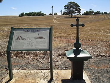
St Johns has an interesting past, especially with its church and school. These buildings played a big part in the community's early days.
The St John the Evangelist Church
The first stone for the St John the Evangelist church was put in place on April 2, 1850. This was a special event, marking the start of building the church. However, the church building took some time to finish. It was finally completed and ready for use on April 30, 1854.
The School and Its Changes
A school opened in St Johns in 1859. This school helped educate the children living in the area. After 1868, the school was run by the Sisters of St Joseph of the Sacred Heart. These sisters were known for their dedication to teaching and caring for children.
A Special School for Girls
From 1897, the school changed its purpose. It became a special institution for girls who needed extra support or guidance. This type of school was sometimes called a "reformatory." It aimed to help these girls learn important life skills and get a good education. The school continued in this role until it closed its doors in 1909.
 | Bessie Coleman |
 | Spann Watson |
 | Jill E. Brown |
 | Sherman W. White |


