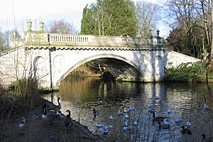
Stamford Brook facts for kids
Stamford Brook was a small river, also called a tributary, in west London. It flowed into the River Thames. This brook had three main starting points, known as headwaters. Long ago, people used its water to help grow crops. This network of small waterways had four places where it met the Thames, called mouths.
Contents
History of Stamford Brook
What's in a Name?
The name "Stamford Brook" might have come from "stoney ford" or "sandy ford." These were places where people crossed the brook, especially near King Street. The area between Hammersmith and Chiswick is now called Stamford Brook because of it. The local London Underground station, Stamford Brook, also shares its name.
Old London Borders
In 1889, when the county of London was formed, Stamford Brook marked an important boundary. It separated areas like Hammersmith and Acton (which were part of London) from Chiswick and Brentford (which were in Middlesex).
Hidden Underground
By the year 1900, all parts of Stamford Brook and its drainage ditches were covered up. These natural dips in the land were perfect for building the area's sewer systems. Many new drains were also created closer to the surface to collect rainwater from the surrounding area.
Not to Be Confused With...
Stamford Brook is not connected to Stamford Bridge. Stamford Bridge is a different place where Kings Road crosses another stream called Counter's Creek. This bridge gives its name to the famous Chelsea Football Club's stadium. Both places are in West London, but they are separate.
Where Stamford Brook Flowed
Starting Points
Stamford Brook had three main starting points, or headwaters:
- Western Start (Bollo Brook): This part, also called Bollo Brook, began near Ealing Common Underground station. It flowed south, then southeast. Part of it went to Chiswick House, and the rest split into four paths that are described below. It flowed east, north of King Street in Chiswick.
* Today, drains for rainwater and dirty water follow the path of this old brook. They run near the Piccadilly and District lines, behind shops on Chiswick High Road. They cross Chiswick Common and the District Line at Turnham Green station, leading to a low area once called Stamford Brook Common. * Freshwater features, like the fishponds near the London Transport Museum Depot (now near Acton Town Underground station), have disappeared. This happened because the land was used for modern drainage systems.
- Eastern Start: This part began on Old Oak Common in Acton. It flowed south along Old Oak Common Road and Old Oak Road, then southeast down Askew Road. This path is now used by separate drains for rainwater and dirty water. It then followed Paddenswick Road, where it joined another flow from Ravenscourt Park.
- Middle Start (The Warple): This part started in North Acton near the A40 road and was known as "the Warple." It flowed south, west of Horn Lane, and under a park called Springfield Gardens. It then turned east under The Woodlands park near Ealing, Hammersmith and West London College in Acton. It ran south of Acton High Street, behind the old Acton Swimming Baths. Finally, it flowed south down Warple Way, where a large sewage pumping station is now located. After this, the brook split near The Brook public house on Stamford Brook Common. One branch went east past Ravenscourt Park and fed its old moat.
Where It Met the Thames
The brook split into several paths as it got closer to the River Thames:
- Hammersmith Creek: The original and middle path flowed south from Paddenswick Road near Ravenscourt Park. It went along Dalling Road, under King Street, and through Hammersmith Registry Office to reach the River Thames. This mouth, once used for boats at high tide, was known as Hammersmith Creek.
- Parr's Ditch: The eastern path, called Parr's Ditch, was more complex. It was used to water fields and help with irrigation in Hammersmith. It continued east through Hammersmith into a natural dip, which is now the long park known as Brook Green. To reach Brook Green, it followed a line parallel to Attwood and Kilmarsh Roads. After Brook Green, it turned south and then southwest, going through Collet Gardens, Wilson, and Yeldham Roads to reach the Thames.
- Chiswick House Channel: A ditch from the western channel was directed to the southern parkland in Chiswick. This helped fill the waters in the grounds of Chiswick House. Its main supply, the Hazeldene, came from a lake near Sydney House to the west. These waters fill the lakes and fountains at Chiswick House and then drain into the River Thames downstream of Barnes Bridge.
- Stamford Green Channel: An extra western channel was added from Stamford Green. It ran underneath Stamford Brook Avenue and British Grove. The land along Stamford Brook Avenue is slightly higher (about 4.8 to 5 meters) than the land in Ravensbourne Park (about 4.2 to 4.4 meters), which was the stream's destination on old maps.
Modern Drainage
Close to the River Thames, the lower parts of these old brook routes are now used for modern sewer systems. These connect to Sir Joseph Bazalgette's Northern Low Level Sewer, which eventually reaches the Northern Outfall Sewer in Stratford. However, during heavy rain, overflow pipes still release water directly into the Thames at Furnival Gardens and Chiswick Eyot. This is why a big project, the Thames Tideway Scheme, is underway. Its goal is to stop this overflow and meet environmental rules.
In 2008, some architects even suggested a bold idea: bringing back Hammersmith Creek by putting the A4 road underground. However, city planners think that while more water might offer nice views, it doesn't create new spaces for recreation or improve air quality.
 | Aurelia Browder |
 | Nannie Helen Burroughs |
 | Michelle Alexander |


