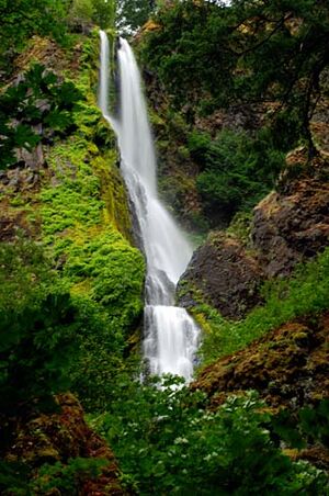
Starvation Creek Falls facts for kids
Quick facts for kids Starvation Creek Falls |
|
|---|---|

Starvation Creek Falls in the Summer
|
|
| Lua error in Module:Infobox_mapframe at line 185: attempt to index field 'wikibase' (a nil value). | |
| Location | Columbia River Gorge |
| Coordinates | 45°41′13″N 121°41′18″W / 45.68699°N 121.68836°W |
| Type | Cascade |
| Elevation | 483 ft (147 m) |
| Total height | 227 |
| Number of drops | 2 |
| Average flow rate |
40 cu ft/s (1.1 m3/s) |
Starvation Creek Falls is a beautiful waterfall in Oregon. It has two main parts, like steps, where the water flows down. You can find it in the Starvation Creek State Park. This park is in Hood River County, right on the edge of the amazing Columbia River Gorge.
This area is very special! Starvation Creek Falls is one of four waterfalls located very close together in Starvation Creek State Park. The others are Cabin Creek Falls, Hole In the Wall Falls, and Lancaster Falls. All four are within two miles of each other along the historic Historic Columbia River Highway. The waterfall and its trails are surrounded by green forests. This area is part of the Columbia Plateau, near a place called Viento Ridge.
The Story Behind the Name
Have you ever wondered how Starvation Creek Falls got its name? It has an interesting history!
A Winter Incident
The waterfall and the creek that feeds it were first called Starveout. This name came from something that happened in the winter of 1884–1885. Two trains from the Union Pacific Railroad got stuck in a big snowstorm. They were marooned, or trapped, near the creek for two whole weeks!
Help Arrives
People had to deliver supplies to the passengers and the train crew. They brought food and other things using skis, sliding over the deep snow. Because of this tough time, the creek was named Starveout. Later, its name was changed to Starvation Creek, which is what we call it today.

