Steart Peninsula facts for kids
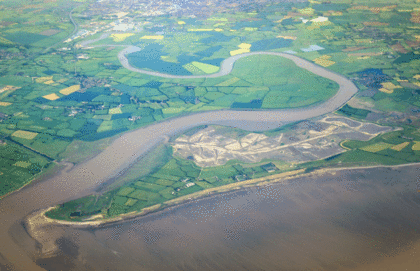
The Steart Peninsula is a piece of land in Somerset, England. It sticks out into the water. At its very end is Stert Point, which is part of the West Somerset Coast Path.
Close by is Stert Island, which used to be connected to the peninsula until around 1798. The peninsula is mostly flat farmland. It sits on the west side of the River Parrett estuary, where the river meets the sea.
The main village on the peninsula is Steart. Other villages like Stockland Bristol and Otterhampton are at its base. A small road connects Steart village to these other places. You can also find the River Parrett Trail here.
West of the peninsula are the villages of Stolford and Hinkley Point. To the south is the village of Combwich.
From 1927 to the 1950s, the mudflats near the peninsula were used by the RAF. They were a place for air gunnery and bombing practice. Some old buildings from that time are still there.
Contents
Exploring Steart Peninsula's Nature
The Steart Peninsula is home to important natural areas. These places protect wildlife and help manage floods. There are two main nature reserves here. A third one is being created by the Royal Society for the Protection of Birds.
Discovering Bridgwater Bay National Nature Reserve
Bridgwater Bay is a special nature reserve on the north side of the peninsula. It has the largest area of salt marsh in Somerset. Salt marshes are coastal wetlands flooded by tides. They are important for many birds.
The reserve also has large mudflats. These areas are uncovered when the tide is low. They are perfect feeding and resting spots for waterfowl and wading birds. You can find four bird hides in the northern part of the reserve. These are great places to watch birds without disturbing them.
Next to the reserve are three coastal common lands. These are Catsford Common, Wall Common, and Steart Common.
Understanding Steart Marshes and Flood Protection
The Steart Marshes are a big wetland reserve on the south side of the peninsula. It was finished in 2014 and is looked after by the Wildfowl and Wetlands Trust. This reserve was built to help manage floods.
The project involved making a gap in the sea wall. This lets seawater flow into the salt marsh from the River Parrett. This helps create a natural barrier against floods.
Why Steart Marshes Were Created
The Steart peninsula has flooded many times over the past 1,000 years. Big floods happened in 1981. By 1997, the sea defenses were weak due to coastal erosion and rising sea levels. They were at risk of breaking.
So, in 2002, the Environment Agency studied ways to protect the coast. In 2010, they planned to turn the peninsula into a wetland. This project cost about £17–20 million. It was the largest wetland creation project in England.
Work started in May 2012 and finished in September 2014. An Environment Agency spokesperson explained that the Steart project protects homes and businesses. Salt marsh is a natural way to manage flood risk. It helps reduce the power of the tide and waves.
 | Tommie Smith |
 | Simone Manuel |
 | Shani Davis |
 | Simone Biles |
 | Alice Coachman |


