Stedman, North Carolina facts for kids
Quick facts for kids
Stedman, North Carolina
|
|
|---|---|

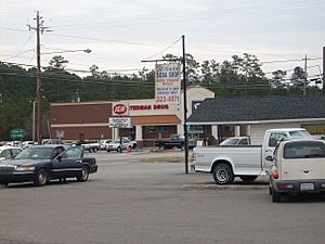
Stedman Soda Shop and Stedman Drug
|
|

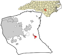
Location in Cumberland County and the state of North Carolina.
|
|
| Country | United States |
| State | North Carolina |
| County | Cumberland |
| Settled | 1841 |
| Incorporated | 1917 |
| Area | |
| • Total | 1.69 sq mi (4.37 km2) |
| • Land | 1.69 sq mi (4.37 km2) |
| • Water | 0.00 sq mi (0.00 km2) |
| Elevation | 128 ft (39 m) |
| Population
(2020)
|
|
| • Total | 1,277 |
| • Density | 756.52/sq mi (292.13/km2) |
| Time zone | UTC-5 (Eastern (EST)) |
| • Summer (DST) | UTC-4 (EDT) |
| ZIP code |
28391
|
| Area codes | 910, 472 |
| FIPS code | 37-64840 |
| GNIS feature ID | 2406663 |
Stedman is a small town located in Cumberland County, North Carolina, in the United States. In 2010, about 1,028 people lived there. The town is named after a brave soldier from the American Civil War, Major Charles Manly Stedman.
Contents
History of Stedman
Stedman began in 1841. A man named John Culbreth Blocker bought some land. He built a stagecoach house and a post office there. A stagecoach was like a bus pulled by horses. It carried people and mail. The town officially became a town, or "incorporated," in 1917.
A special old building called the Maxwell House is in Stedman. It was added to the National Register of Historic Places in 1985. This means it's an important historical place.
Geography and Location
Stedman is found in the eastern part of Cumberland County. North Carolina Highway 24 goes right through the town. If you drive west on this highway for about 11 miles, you will reach Fayetteville. Fayetteville is the main city and the "county seat" of Cumberland County. This means it's where the county government offices are. If you drive east for about 22 miles, you will get to Clinton.
The United States Census Bureau says that Stedman covers about 1.69 square miles (4.37 square kilometers) of land. There is no water area within the town limits.
People of Stedman
Every ten years, the United States counts its population. This is called a census. It helps us understand how many people live in a place and what groups they belong to.
Here is how Stedman's population has grown over the years:
| Historical population | |||
|---|---|---|---|
| Census | Pop. | %± | |
| 1920 | 121 | — | |
| 1930 | 289 | 138.8% | |
| 1940 | 356 | 23.2% | |
| 1950 | 424 | 19.1% | |
| 1960 | 458 | 8.0% | |
| 1970 | 505 | 10.3% | |
| 1980 | 723 | 43.2% | |
| 1990 | 577 | −20.2% | |
| 2000 | 664 | 15.1% | |
| 2010 | 1,028 | 54.8% | |
| 2020 | 1,277 | 24.2% | |
| U.S. Decennial Census | |||
2020 Census Information
The most recent count was in 2020. At that time, 1,277 people lived in Stedman. There were 501 households, which are like homes where people live together. Out of these, 329 were families.
Here's a look at the different groups of people living in Stedman in 2020:
| Group | Number of People | Percentage of Total |
|---|---|---|
| White (not Hispanic) | 939 | 73.53% |
| Black or African American (not Hispanic) | 129 | 10.1% |
| Native American | 15 | 1.17% |
| Asian | 8 | 0.63% |
| Other/Mixed (more than one race) | 105 | 8.22% |
| Hispanic or Latino | 81 | 6.34% |
See also
- If you want to read about Stedman in Spanish, you can find information here: Stedman para niños
 | John T. Biggers |
 | Thomas Blackshear |
 | Mark Bradford |
 | Beverly Buchanan |

