Stefansson Island facts for kids

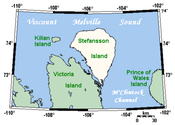
Stefansson Island and surrounding area
|
|
| Geography | |
|---|---|
| Location | Viscount Melville Sound |
| Coordinates | 73°20′N 105°45′W / 73.333°N 105.750°W |
| Archipelago | Arctic Archipelago |
| Area | 4,463 km2 (1,723 sq mi) |
| Highest elevation | 256 m (840 ft) |
| Highest point | unnamed |
| Administration | |
|
Canada
|
|
| Territory | Nunavut |
| Region | Kitikmeot |
| Demographics | |
| Population | 0 |
Stefansson Island is a large island in the Arctic Archipelago of Canada. It is located in the Nunavut territory. No people live on Stefansson Island. It is known as an "uninhabited" island.
The island covers an area of about 4,463 square kilometers (1,723 square miles). This makes it the 128th largest island in the world. It is also Canada's 27th largest island.
Contents
Where is Stefansson Island?
Stefansson Island is found in a body of water called Viscount Melville Sound. To its east is the M'Clintock Channel.
The island lies very close to Victoria Island. A narrow waterway called the Goldsmith Channel separates them. The highest point on Stefansson Island is about 256 meters (840 feet) tall.
Arctic Weather Station
There is a special weather station on the northern part of Stefansson Island. This station helps scientists learn about the weather in the Arctic. It is an automated station, meaning it works by itself.
The weather station is part of a network run by Environment and Climate Change Canada. This group collects important weather data from across the Arctic region.
How Stefansson Island Was Discovered
The first European to see Stefansson Island was Storker T. Storkerson. This happened in 1917. He was exploring with a famous Canadian explorer named Vilhjalmur Stefansson.
The island was later named after Vilhjalmur Stefansson. This was to honor his work in exploring the Arctic.
See also
 In Spanish: Isla Stefansson para niños
 | Aurelia Browder |
 | Nannie Helen Burroughs |
 | Michelle Alexander |


