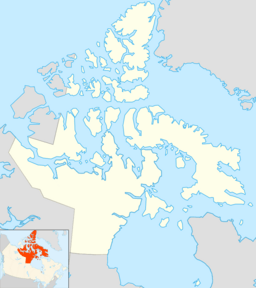
M'Clintock Channel facts for kids
Quick facts for kids M'Clintock Channel |
|
|---|---|
| Coordinates | 72°00′N 102°00′W / 72.000°N 102.000°W |
| Basin countries | Nunavut, Canada |
| Max. length | 270 km (170 mi) |
| Max. width | 105 to 209 km (65 to 130 mi) |
The M'Clintock Channel (sometimes spelled McClintock Channel) is a large waterway in the Arctic Ocean. It is located in Nunavut, a huge territory in northern Canada. This channel acts like a big divider, separating Victoria Island from Prince of Wales Island.
The channel gets its name from Sir Francis McClintock. He was an Irish explorer who worked for the Royal Navy in Britain. Sir Francis became famous for his many trips and explorations in the Canadian Arctic region.
This channel is quite long, stretching about 170 miles (274 kilometers). It is also very wide, measuring between 65 to 130 miles (105 to 209 kilometers) across. These measurements make it one of the biggest channels in the Arctic Archipelago, which is a large group of islands in the Arctic.
The M'Clintock Channel connects to other important bodies of water. To its northwest, it links up with Ommanney Bay and the Parry Channel. To the southeast, it connects to Larsen Sound. A place called Umingmalik is located on the southeastern edge of the channel.
See also
 In Spanish: Canal M'Clintock para niños
 | Anna J. Cooper |
 | Mary McLeod Bethune |
 | Lillie Mae Bradford |


