Steinfurt Rural District facts for kids
Quick facts for kids
Steinfurt
|
|||
|---|---|---|---|
|
|||
 |
|||
| Country | |||
| State | North Rhine-Westphalia | ||
| Adm. region | Münster | ||
| Capital | Steinfurt | ||
| Area | |||
| • Total | 1,792.097 km2 (691.933 sq mi) | ||
| Population
(2002)
|
|||
| • Total | 438,765 | ||
| • Density | 244.8333/km2 (634.1153/sq mi) | ||
| Time zone | UTC+1 (CET) | ||
| • Summer (DST) | UTC+2 (CEST) | ||
| Vehicle registration | ST | ||
| Website | http://www.kreis-steinfurt.de | ||
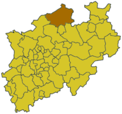
Steinfurt is a special kind of area in Germany called a Kreis, which is like a district or county. It's located in the northern part of North Rhine-Westphalia, one of Germany's states. Steinfurt is surrounded by several other districts. These include Bentheim and Emsland in the state of Lower Saxony, plus Osnabrück (a city) and the Osnabrück district. It also borders Warendorf, Münster (another city), Coesfeld, and Borken.
Contents
Discovering Steinfurt's Location
The Steinfurt district is right next to the border of Lower Saxony, another German state. It's located north of the city of Münster. A major river, the Ems, flows through the district. It starts in the south and moves towards the north.
Highs and Lows: Steinfurt's Landscape
Steinfurt has varied landscapes, from hills to lower areas. The highest point you can find in the district is a place called Westerbecker Berg. It stands tall at 234 meters (about 768 feet) above sea level. On the other hand, the lowest point is near Bentlage castle, which is only 32 meters (about 105 feet) above sea level.
A Journey Through Steinfurt's Past
Steinfurt has a long and interesting history. In the late Middle Ages, it became its own independent area, known as an earldom.
Steinfurt's Early Independence
Initially, Steinfurt was part of another earldom called Bentheim. But in 1454, Steinfurt became independent. This meant it had its own rulers and was no longer controlled by Bentheim.
Changes and Mergers Over Time
History continued to shape Steinfurt. In 1804, it was joined back with Bentheim for a short time. Then, in 1815, Steinfurt became part of Prussia. Prussia was a powerful kingdom in Germany, and Steinfurt joined its province of Westphalia. The new Prussian government created the districts of Steinfurt and Tecklenburg in 1816.
How Modern Steinfurt Was Formed
The Steinfurt district we know today was created in 1975. This happened when the old Steinfurt district merged with the Tecklenburg district. Also, parts of the old Münster district, specifically the towns of Greven and Saerbeck, were added to form the current district.
Understanding Steinfurt's Coat of Arms
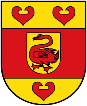
The coat of arms for the Steinfurt district is a special symbol. It combines different parts from the coats of arms of the older districts: Steinfurt, Tecklenburg, and Münster.
Symbols on the Coat of Arms
- The swan in the middle of the coat of arms comes from the old earldom of Steinfurt. This swan represents the heart of the district.
- The red bar that goes around the swan stands for the church-controlled state of Münster. This area used to surround the dukedom of Steinfurt.
- The red water lily leaves are symbols of the dukes who ruled Tecklenburg.
Towns and Municipalities in Steinfurt
The Steinfurt district is made up of several towns and smaller communities called municipalities. Each of these places has its own unique character and history.
Major Towns in the District
- Emsdetten
- Greven
- Hörstel
- Horstmar
- Ibbenbüren
- Lengerich
- Ochtrup
- Rheine
- Steinfurt
- Tecklenburg
Local Municipalities in Steinfurt
- Altenberge
- Hopsten
- Ladbergen
- Laer
- Lienen
- Lotte
- Metelen
- Mettingen
- Neuenkirchen
- Nordwalde
- Recke
- Saerbeck
- Westerkappeln
- Wettringen
 | Sharif Bey |
 | Hale Woodruff |
 | Richmond Barthé |
 | Purvis Young |


