Stollings, West Virginia facts for kids
Quick facts for kids
Stollings, West Virginia
|
|
|---|---|
| Country | United States |
| State | West Virginia |
| County | Logan |
| Area | |
| • Total | 0.384 sq mi (0.99 km2) |
| • Land | 0.359 sq mi (0.93 km2) |
| • Water | 0.025 sq mi (0.06 km2) |
| Elevation | 673 ft (205 m) |
| Population
(2010)
|
|
| • Total | 316 |
| • Density | 880.2/sq mi (339.8/km2) |
| Time zone | UTC-5 (Eastern (EST)) |
| • Summer (DST) | UTC-4 (EDT) |
| ZIP code |
25646
|
| Area code(s) | 304 & 681 |
| GNIS feature ID | 1547442 |
| FIPS code | 54-76996 |
Stollings is a small place in Logan County, West Virginia, United States. It's known as an unincorporated community, which means it's not officially a town or city with its own local government. It's also a census-designated place (CDP), which is an area the government counts for population statistics. In 2010, about 316 people lived there.
Exploring Stollings' Location
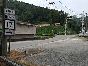
Stollings is found in the middle part of Logan County. It sits right by the Guyandotte River. This community is where two important roads, West Virginia Route 10 and West Virginia Route 17, meet.
Where is Stollings?
Stollings is located about 1.5 miles (2.4 km) east-southeast of Logan. Logan is the main town, or county seat, of Logan County. Stollings is also very close to the city of Logan, just to its southeast. Another community called McConnell is located just south of Stollings.
Stollings' Size and Waterways
The total area of Stollings is about 1.0 square kilometer (0.38 square miles). A small part of this area, about 6.39%, is water. This is because Stollings is where a stream called Dingess Run flows into the Guyandotte River. The community also has its own post office with the ZIP code 25646.
See also
 In Spanish: Stollings (Virginia Occidental) para niños
 | James Van Der Zee |
 | Alma Thomas |
 | Ellis Wilson |
 | Margaret Taylor-Burroughs |


