Stone Bridge, Dalrymple Gap Track facts for kids
Quick facts for kids Stone Bridge, Dalrymple Gap Track |
|
|---|---|

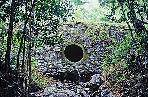
Stone Bridge, Dalrymple Gap Track, lower side, 1993
|
|
| Location | Valley of Lagoons Road, Damper Creek, Cassowary Coast Region, Queensland, Australia |
| Design period | 1840s - 1860s (mid-19th century) |
| Built | 1864 - 1865 |
| Official name: Stone Bridge, Dalrymple Gap Track | |
| Type | state heritage (built) |
| Designated | 21 October 1992 |
| Reference no. | 600393 |
| Significant period | 1860s (fabric) 1865-1872 (historical main period of use of road) |
| Significant components | embankment - road, culvert - stream |
| Lua error in Module:Location_map at line 420: attempt to index field 'wikibase' (a nil value). | |
The Stone Bridge, Dalrymple Gap Track is a very old road bridge located in Queensland, Australia. You can find it on Valley of Lagoons Road, near Damper Creek in the Cassowary Coast Region. This special bridge was built a long time ago, between 1864 and 1865. It is so important that it is listed on the Queensland Heritage Register, which means it is protected because of its history. It was added to the register on October 21, 1992.
Contents
Building the Dalrymple Gap Track
The stone and brick culvert, which is like a small bridge, was built in late 1864 and early 1865. It was part of the very first big engineering project in North Queensland. This project was to build the Dalrymple Gap Track. This track connected Cardwell to the inland areas, including the Valley of Lagoons on the upper Burdekin River.
Exploring the Land
In 1863, an explorer named George Elphinstone Dalrymple and his partners started a large farm called the Valley of Lagoons. This farm was separated from the coast by two thick mountain ranges. In early 1864, Dalrymple sailed to Rockingham Bay (near what is now Cardwell). He set up a new town there, which he named Cardwell.
After setting up the town, Dalrymple wanted to find a way to get wagons from the coast to the inland farm. He first tried to go through the Cardwell Range but didn't succeed. Then, he found an Aboriginal path that led directly to a place called Dalrymple Gap. This gap was about 10 miles south of Cardwell.
Beyond the gap was the Herbert River valley, and then another mountain range. Crossing this range was very difficult. Finally, they reached the Valley of Lagoons. On their way back, Dalrymple's group cleared a rough track for wagons to the coast.
Funding the Road Project
In the second half of 1864, the Queensland government gave £2,000 to help build the road. A government team was sent to Cardwell. Dalrymple worked with Mr. Conlan, the team's overseer, to plan the road through Dalrymple Gap. They managed to shorten the road from 36 miles to 28 miles.
Mr. Conlan and his team worked on the coastal side of Dalrymple Gap. The western side of the route was divided into three sections, each 1.5 miles long, to make the work go faster.
By January 20, 1865, the government team had finished building a road with an easy slope on the coastal side. It is likely that the Stone Bridge was built around this time. Dalrymple wrote in a letter on February 22, 1865, that the road would be finished by the end of March. This included cutting down trees, removing obstacles, and building "substantial culverts" (like the bridge) where needed.
The Road's Busy Years
The Dalrymple Gap Track was used most often between 1864 and 1872. In the late 1860s and early 1870s, farmers started growing sugar and raising animals in the Herbert River valley. By early 1871, nearly 100 people lived there.
Later, a new path was found from the Herbert River to Cardwell through Cardwell Gap. This path was then turned into a wagon road. After this new road opened in October 1872, people didn't need to use the much steeper Dalrymple Gap route as much. However, the Cardwell Divisional Board still paid for occasional repairs until the early 1890s.
Since 1987, the Queensland Forest Service has looked after the Dalrymple Gap Track. Most of the track, including the stone bridge, became part of the Lumholtz National Park in 1992. This park is now called the Girringun National Park. The track is still a popular place for bushwalking today. The bridge was also repaired in 2001 to help preserve it.
What the Stone Bridge Looks Like
The Stone Bridge on the Dalrymple Gap Track is located on the eastern side of the Cardwell Range. It is about 200 meters from Dalrymple's Gap. It crosses a deep, narrow valley called Damper Creek. The bridge is actually a brick-lined culvert built into a stone embankment.
The embankment (the raised road surface) is about 6 meters wide at the top and 20 meters long. It is 5.5 meters high on one side and 7 meters high on the other. It is made of stone rubble and soft mortar. It has one round tunnel, about 1.5 meters wide, that lets water flow under the road during the wet season. This tunnel is lined with two layers of bricks.
Why This Bridge is Special
The Stone Bridge, Dalrymple Gap Track, was listed on the Queensland Heritage Register on October 21, 1992, because it meets several important requirements.
Showing Queensland's History
This Stone Bridge is important because it shows how Queensland developed in the mid-1860s. Back then, it was very important to connect farms in the inland areas with the coast. This allowed goods to be moved and helped new towns grow.
The bridge also has a connection to George Dalrymple, who was an important early explorer in North Queensland.
A Rare Piece of History
This bridge is special because it is the oldest stone bridge or culvert still standing in Queensland. It is also the earliest surviving civil engineering project in mainland North Queensland. This makes it a very rare and important part of the state's history.
A Great Example of Engineering
The bridge is still mostly in its original condition. It is an excellent example of how culverts were built in the mid-1800s, especially in difficult mountain areas.
Beautiful Scenery
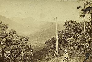
The area around the bridge is very beautiful. The road was built in 1864-65, making this lovely scenery accessible to visitors. People have admired this area since the very first European settlements, and it was a popular spot for picnics in the 1870s.
 | Jewel Prestage |
 | Ella Baker |
 | Fannie Lou Hamer |


