Damper Creek, Queensland facts for kids
Quick facts for kids Damper CreekQueensland |
|||||||||||||||
|---|---|---|---|---|---|---|---|---|---|---|---|---|---|---|---|
| Population | 34 (2021 census) | ||||||||||||||
| • Density | 0.2066/km2 (0.535/sq mi) | ||||||||||||||
| Postcode(s) | 4849 | ||||||||||||||
| Area | 164.6 km2 (63.6 sq mi) | ||||||||||||||
| Location | |||||||||||||||
| LGA(s) | Cassowary Coast Region | ||||||||||||||
| State electorate(s) | Hinchinbrook | ||||||||||||||
| Federal Division(s) | Kennedy | ||||||||||||||
|
|||||||||||||||
Damper Creek is a small coastal area in Queensland, Australia. It's part of the Cassowary Coast Region. In 2021, only 34 people lived there. It's a quiet place by the sea.
Where is Damper Creek?
Damper Creek is right next to the Hinchinbrook Channel. This channel separates the mainland from Hinchinbrook Island. It's a beautiful waterway.
The main road, called the Bruce Highway, goes through Damper Creek. It runs from the south to the north. A railway line, the North Coast railway line, also passes through. It runs next to the highway.
Most of Damper Creek is flat land near the coast. It's mostly undeveloped. Some areas are used for farming seafood, like prawns or fish. In the northwest and southwest, the land goes up steeply. These are parts of the Cardwell Range mountains.
How Many People Live Here?
Damper Creek is a very small community. In 2016, there were 49 people living there. By 2021, the population had changed to 34 people.
Old Places to See
Damper Creek has some special places that are protected because of their history. These are called heritage-listed sites.
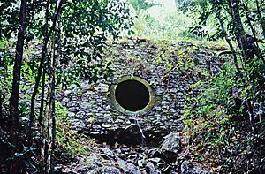
One important site is the Stone Bridge, Dalrymple Gap Track. It's located on Valley of Lagoons Road. This old stone bridge is a cool reminder of the past.
 | Emma Amos |
 | Edward Mitchell Bannister |
 | Larry D. Alexander |
 | Ernie Barnes |


