
Hinchinbrook Island facts for kids
|
Native name:
Pouandai
|
|
|---|---|

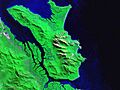
Hinchinbrook Island looking west (i-cubed Landsat 7).
|
|

Hinchinbrook
Location in Queensland
|
|
| Geography | |
| Location | Coral Sea |
| Coordinates | 18°13′46″S 146°13′58″E / 18.22944°S 146.23278°E |
| Total islands | great barrier reef |
| Area | 393 km2 (152 sq mi) |
| Length | 52 km (32.3 mi) |
| Width | 10 km (6 mi) |
| Highest elevation | 1,121 m (3,678 ft) |
| Highest point | Mount Bowen |
| Administration | |
|
Australia
|
|
| State | Queensland |
| LGA | Cassowary Coast Region |


Hinchinbrook Island, also known as Pouandai by its first people, is a large island off the coast of Queensland, Australia. It's located near the towns of Cardwell and Lucinda. A narrow waterway called the Hinchinbrook Channel separates it from the mainland.
This amazing island is part of the Great Barrier Reef Marine Park. Most of it is protected as Hinchinbrook Island National Park. It's actually the biggest island in the Great Barrier Reef and Australia's largest island national park!
Contents
Discover Hinchinbrook Island's Natural Wonders
Hinchinbrook Island was formed from ancient volcanic rocks. Over time, the land was pushed up, creating the tall mountains we see today. The Hinchinbrook Channel separating the island from the mainland was likely formed by a fault in the Earth's crust.
How Hinchinbrook Island Formed
About 18,000 years ago, after the last Ice Age, sea levels rose. What was once a rugged coastal mountain range became Hinchinbrook Island. To the west, the Hinchinbrook Channel is filled with thick mangrove forests. This channel is actually a flooded valley of the Herbert River. For millions of years, the island was connected to the mainland by dry land. Today, it's only separated when sea levels are high.
East of Hinchinbrook Island is the Coral Sea, home to the Great Barrier Reef. To the north, you'll find other islands like Goold Island and the Brook Islands Group. South of Hinchinbrook, the Cardwell Range leads to the Herbert River's wide floodplain.
Explore the Island's Diverse Ecosystems
Missionary Bay, at the northern end of the national park, is a very special place. It has about 50 square kilometers of dense mangrove forests along its shore. Many scientists believe these mangrove forests are the most diverse in Australia, with 31 different types of mangroves!
In the shallow waters, you'll find large beds of seagrass. These are important feeding grounds for dugongs. The beach stone-curlew, a type of bird, also thrives here because vehicles are not allowed on the beaches, keeping them safe.
The eastern coast of Hinchinbrook Island has rocky headlands, hidden sandy beaches, and sand dunes. Mangroves grow near freshwater streams. At Ramsay Bay, a sandy barrier connects a granite outcrop called Cape Sandwich to the main island. This barrier was formed by wind-blown sands over thousands of years.
Meet the Island's Wildlife
Hinchinbrook Island is known as a "wilderness area." It's wild and rugged, with towering mountain peaks. The highest mountain is Mount Bowen, which stands 1,121 meters (about 3,678 feet) above sea level. Other tall peaks include The Thumb (981 meters) and Mount Diamantina (953 meters).
The island's plant life includes thick shrubs, heath, bushland, and forests. This diverse habitat provides a safe home for many endangered species, including the giant tree frog.
The island has a tropical climate. Winters are warm to mildly cool and dry. Summers are hot, humid, and rainy, which is also when tropical cyclones can occur. The waters around the island don't have many coral reefs, likely because of the freshwater runoff from the island.
Hinchinbrook Island's Rich History
Hinchinbrook Island, or Pouandai, was originally home to the Biyaygiri Aboriginal people.
The Warrgamay Language and Culture
The Warrgamay language was spoken by Aboriginal people in this region. This included areas around the Herbert River, Ingham, Cardwell, Hinchinbrook Island, and the nearby mainland.
Evidence of the Biyaygiri people's activities can still be seen today, such as shell middens (piles of shells from their meals) and fish traps. Fish were a very important food source. The Bandjin fish traps, made of rocks, used the changing tides to catch fish. They even kept the fish alive for days! Sometimes, many fish would be caught, and they would be left for the birds to eat. These traps still feed local birds today.
European Exploration and Naming
In 1770, British Captain James Cook sailed past the island on his ship, the HMS Endeavour. He named Mount Hinchinbrook, but he didn't realize it was an island at the time. Later, in 1819, Lieutenant Phillip Parker King suspected it was an island but couldn't confirm it.
It wasn't until 1843, when Captain Blackwood on HMS Fly spent two weeks in the area, that the British confirmed it was a separate landmass. They named it Hinchinbrook Island after Hinchingbrooke House in England. This was a way for Cook to thank John Montagu, 4th Earl of Sandwich, who was an important leader in the British Navy.
Early Encounters and Changes
Early meetings between British explorers and the Biyaygiri people were mostly friendly. However, as more Europeans arrived, relations became difficult. After the town of Cardwell was established in 1864, conflicts increased. The Aboriginal population on Hinchinbrook Island quickly decreased.
In 1874, Reverend Edward Fuller tried to start a mission on the island, but he had to leave because he didn't see any Aboriginal people there for nine months.
Over the next few decades, Europeans settled on Hinchinbrook Island. They mainly fished, farmed, and mined. In 1932, Hinchinbrook Island was declared a national park, protecting its natural beauty.
World War II and Nim's Island
During World War II in 1942, an American B-24 Liberator bomber crashed into Mount Straloch on the island. All 12 crew members sadly died. After the war, too much crocodile hunting almost made them disappear by the 1960s.
More recently, in 2008, parts of the movie Nim's Island were filmed on Hinchinbrook Island!
Visiting Hinchinbrook Island: Tourism and Adventure
Hinchinbrook Island used to have a place to stay called the Hinchinbrook Island Wilderness Lodge. However, it closed in 2010 due to money problems and was later damaged by Cyclone Yasi.
Popular Destinations and Rules for Visitors
Hinchinbrook Island, the Hinchinbrook Channel, and the nearby coastal plain are a special natural area.
One of the most famous attractions is the 32 km (20 mi) long Thorsborne Trail. This hiking trail usually takes 3-4 days to complete. It's named after environmental activists Arthur and Margaret Thorsborne.
You can enjoy many activities in the marine park, like sightseeing cruises, sailing, outrigger canoeing, swimming, snorkeling, and scuba diving. Sea kayaking is popular on the east side of the island. However, on the west side, the island is known to be a habitat for saltwater crocodiles, so caution is needed.
If you want to camp on Hinchinbrook Island, you need a permit. The number of visitors is limited to help protect the island's amazing biodiversity and prevent damage to the environment. Open fires are not allowed.
How to Get to Hinchinbrook Island
The Bruce Highway connects major towns like Townsville, Lucinda, Cardwell, and Cairns. You can take a bus from Cardwell or Ingham. Some shuttle services also run from Ingham to Lucinda for hikers going on the Thorsborne Trail. Queensland Rail also has train services to Cardwell.
Shipwreck Discovery
In 2011, a fisherman found the shipwreck of a thirty-metre (98-foot) longboat on the shores of Ramsay Bay. It's believed the wreck is about 130 years old and was uncovered by Cyclone Yasi.
Images for kids
-
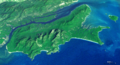
Hinchinbrook Island looking west (i-cubed Landsat 7).
-
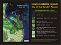
Map showing land cover
-
The climate of Cardwell (note the precipitation scale: maximum 2000mm/a).
-
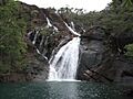
Zoe Falls
-
False-colour image of Hinchinbrook Island
-
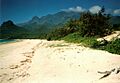
Nina Peak and the cloud shrouded Mount Bowen from the beach at Ramsay Bay.
-
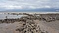
Scraggy Point stone fish traps
