Herbert River facts for kids
Quick facts for kids Herbert |
|
|---|---|

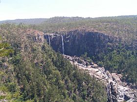
The Herbert River flowing over the Blencoe Falls, 2006
|
|
|
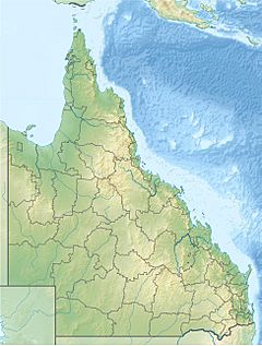
Location of Herbert River river mouth in Queensland
|
|
| Country | Australia |
| State | Queensland |
| Region | Far North Queensland, Wet Tropics of Queensland |
| City | Ingham |
| Physical characteristics | |
| Main source | Atherton Tableland, Great Dividing Range |
| River mouth | Coral Sea Hinchinbrook Channel 0 m (0 ft) 18°32′16″S 146°17′21″E / 18.53778°S 146.28917°E |
| Length | 288 km (179 mi) |
| Basin features | |
| Basin size | 10,130 km2 (3,910 sq mi) |
| Tributaries |
|
| Waterfalls | Herbert River Falls, Blencoe Falls, Millstream Falls |
The Herbert River is an important river in Far North Queensland, Australia. It is the most southern river system in Queensland's wet tropics region. The river was named in 1864 by explorer George Elphinstone Dalrymple. He named it after Robert Herbert, who was the very first Premier of Queensland.
Contents
Herbert River: Location and Features
The Herbert River begins high up on the Atherton Tableland. This area is part of the Great Dividing Range. The river's starting point, called its headwaters, is about 1070 meters above sea level.
Where the River Flows
The Herbert River starts when two smaller rivers, the Millstream and the Wild River, join together. This joining point is called a confluence. From there, the Herbert River generally flows southeast. It passes through the Girringun National Park. Along its journey, fifteen smaller streams, known as tributaries, flow into it. One of these is the Stone River. The Herbert River also flows past the town of Ingham.
The river finally reaches its mouth where it empties into the Coral Sea. This is near a place called Lucinda, at the southern end of the Hinchinbrook Channel. This mouth is about 130 kilometers north of Townsville. Over its 288-kilometer course, the river drops about 642 meters in elevation.
River Catchment Area
The Herbert River's catchment area is a large region of land where all the rain and water eventually flow into the river. This area covers about 10,130 square kilometers. Many creeks contribute to the Herbert River. For example, Blunder, Sunday, and Cameron Creeks flow from the Cardwell Range. Further south, Nanyeta (Return) and Rudd Creeks come from the Great Dividing Range.
Amazing Waterfalls
The Herbert River system is home to some incredible waterfalls.
- The Wallaman Falls are on Stony Creek, which is a tributary of the Herbert. These falls are Australia's tallest single-drop waterfall!
- Other beautiful waterfalls on the river include the Herbert River Falls, Blencoe Falls, and Millstream Falls.
Flooding in the Herbert River
When there is a lot of rain, especially during the wet season, the Herbert River can rise very quickly. This is common in the lower areas around Ingham. Sometimes, up to 600 millimeters of rain can fall in just a few days.
When the river floods, water can be up to 3 meters deep in the lower parts of Ingham. This means people living in these areas often need to move to higher ground for safety. The river had a very big flood during the 2010–2011 Queensland floods.
People and Land Use Along the Herbert River
The land around the Herbert River has been home to Aboriginal people for thousands of years.
- The Warrgamay people have strong connections to this area. Their language region includes the Herbert River area, Ingham, and nearby islands like Hinchinbrook Island.
- The Warungu people also have a connection to this land. Their language region stretches from the Upper Herbert River towards Mount Garnet.
About 18,000 people live in the Herbert River catchment area. Most of them live in the lower flood plain.
How the Land is Used
The upper parts of the Herbert River region are mainly used for raising cattle. Further down, the flat areas near the river are used to grow lots of sugar cane. The middle parts of the catchment area include important National Parks and State Forests. These areas are part of the Wet Tropics World Heritage Area, which is protected because of its unique nature.
River Adventures and History
Parts of the Herbert River, especially the Herbert River Gorge, are popular for exciting activities. People enjoy kayaking and white water rafting here. The Herbert River is known as one of Australia's best places for long whitewater journeys.
The second season of the American reality TV show Survivor was filmed in the upper Herbert River region. This was on a cattle station called "Goshen," near the Blencoe Falls and Herbert River Gorge.
The Herbert River, along with the Tully and the Burdekin rivers, was once part of a big plan called the Bradfield Scheme. This plan, proposed in 1938, aimed to divert the upper parts of these three rivers. The idea was to send their water west of the Great Dividing Range into the Thomson River. This would have helped irrigate and prevent droughts in much of Central West Queensland and parts of South Australia. However, the plan was abandoned in 1947.
 | Precious Adams |
 | Lauren Anderson |
 | Janet Collins |


