Cyclone Yasi facts for kids

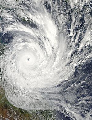
Cyclone Yasi approaching Queensland near peak intensity on 2 February 2011
|
|
| Meteorological history | |
|---|---|
| Formed | 26 January 2011 |
| Remnant low | 3 February 2011 |
| Dissipated | 6 February 2011 |
| Category 5 severe tropical cyclone | |
| 10-minute sustained (Aus) | |
| Highest winds | 205 km/h (125 mph) |
| Highest gust | 285 km/h (180 mph) |
| Lowest pressure | 929 hPa (mbar); 27.43 inHg |
| Category 4 tropical cyclone | |
| 1-minute sustained (SSHWS/JTWC) | |
| Highest winds | 250 km/h (155 mph) |
| Lowest pressure | 922 hPa (mbar); 27.23 inHg |
| Overall effects | |
| Fatalities | 1 indirect |
| Damage | $3.6 billion (2011 USD) (Costliest tropical cyclone in the Australian region basin) |
| Areas affected | Tuvalu, Fiji, Solomon Islands, Vanuatu, Papua New Guinea, Australia |
|
Part of the 2010–11 South Pacific and Australian region cyclone seasons |
|
Severe Tropical Cyclone Yasi was a very strong and damaging tropical cyclone. It hit northern Queensland, Australia, in early 2011. This storm caused a lot of damage in the areas it passed through.
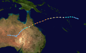
Yasi started as a small weather system near Fiji on January 26. It grew stronger and became a tropical cyclone by January 30. Over the next day, Yasi quickly got much stronger. It became a Category 3 cyclone on January 31. By February 2, it was a Category 5 Severe Tropical Cyclone, which is the strongest type. It had a clear eye in its center.
On February 3, around midnight, Yasi hit the Australian coast near Mission Beach. It was still a Category 5 storm. The winds were incredibly strong, with gusts up to 285 km/h (177 mph). The lowest air pressure ever recorded in the area, 929 hPa, was measured as the eye passed over Tully. Because Yasi was so big and powerful, it stayed strong even far inland. It finally weakened into a tropical low near Mount Isa on February 3, about 22 hours after hitting the coast.
The storm caused about AU$3.5 billion (US$3.6 billion) in damage. This made it the most expensive tropical cyclone to hit Australia at that time. Yasi was also indirectly linked to the death of one person. This person died from breathing in fumes from a generator.
Cyclone Yasi was the biggest storm in Queensland's history. More than 10,000 people had to leave their homes. The storm passed between the large cities of Cairns and Townsville. These cities only had minor damage. Early estimates thought the damage would be around AU$100 million. The actual damage was less than expected because the storm missed the main cities. However, it destroyed 30% of the houses in Tully. At least 75% of the banana crops were ruined. Damage to sugar cane farms was expected to cost about AU$500 million. Power lines were damaged, leaving 150,000 homes without electricity.
Contents
How Did Cyclone Yasi Form?
The storm that became Yasi was first noticed on January 26, 2011. It was identified by the Fiji Meteorological Service (FMS). At this time, it was a tropical disturbance about 330 km (205 mi) south-southwest of Tuvalu. The ocean water was warm, and there wasn't much wind shear (changes in wind speed or direction with height). These conditions were good for the storm to grow.
For the next two days, the storm didn't change much. It was called a tropical depression on January 27. By January 28, it was a weak low-pressure system with swirling clouds. On January 29, it started to develop much more quickly. The Joint Typhoon Warning Center (JTWC) then issued a warning that a tropical cyclone might form. The center of the storm became clearer, and bands of rain clouds started to form around it.
Yasi Becomes a Strong Cyclone
On January 30, Yasi quickly became stronger. The JTWC upgraded it to a tropical storm. This was because satellite images showed strong winds around the storm's center. Soon after, the FMS also called it Tropical Cyclone Yasi. When it became a tropical cyclone, Yasi was about 370 km (230 mi) northeast of Vanuatu.
The storm moved west, passing through the northern islands of Vanuatu. It continued to get stronger very fast. On January 31, Yasi became a severe tropical cyclone. This means its winds were at least 120 km/h (75 mph). Later that day, the storm moved into the area watched by the Australian Bureau of Meteorology (BoM).
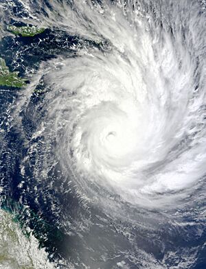
After entering the BoM's area, Yasi grew even more powerful. It was in very good conditions for strengthening. A shallow eye formed by January 31. As the storm got stronger, a clear, round eye developed. Yasi reached Category 4 strength late on February 1. It became a Category 5 storm early on February 2. At its strongest, Yasi had winds of 125 mph (201 km/h) and a pressure of 929 hPa.
Yasi traveled southwest and stayed a very powerful storm. It made landfall near Mission Beach, Queensland, on February 2. After hitting land, the storm quickly weakened. It was no longer a severe tropical cyclone just six hours later. For the next few days, the storm moved slowly as a weak low-pressure system over Australia. It finally disappeared on February 6.
Preparing for the Storm and Its Effects
Severe Tropical Cyclone Yasi directly hit the Solomon Islands, Vanuatu, and parts of Australia. Some parts of Fiji and Papua New Guinea were also affected indirectly. Because of the damage it caused, the name Yasi was removed from the list of cyclone names. It was replaced with Yvonne.
Impact on Nearby Islands
Between January 23 and 30, strong winds and big waves were seen in Tuvalu. This happened as two cyclones, Wilma and Yasi, formed and passed by. These strong winds caused delays in shipping. Students traveling between islands and to Fiji were affected. Some outer islands ran out of fresh supplies because the seas were too rough. From January 28 to 30, the storm that became Yasi brought rain and strong winds to the Fijian islands.
On January 30, Yasi became the second of three storms to hit Vanuatu in two months. Tropical Cyclone Yasi moved across Vanuatu's northern Torba Province. Winds reached up to 95 km/h (60 mph). Officials in Vanuatu had trouble contacting the Torba Province. However, it was thought that the northern area avoided major damage.
The storm was several hundred kilometers southeast of Papua New Guinea. But the outer parts of the large storm brought strong winds, high seas, and heavy rain to the country. In Milne Bay Province, local officials told people living along the coast to move to higher ground.
Willis Island Weather Station
As Yasi moved towards Australia, weather data from the station on Willis Island helped track the storm. Before the storm hit the island, staff secured the buildings. They were then flown off the island by helicopter on February 1. Yasi passed directly over the weather station on February 2. Wind gusts of 185 km/h (115 mph) and a very low pressure of 937.9 hPa were recorded. After this, the weather equipment and communications stopped working.
After the storm passed, it was clear that the strong winds and storm surge had damaged the radar and other important systems. The island's shape had also changed, and most of its plants were gone. Most of the automated weather systems and communications were fixed within 15 days. However, the radar and other life-support systems took longer. They were fixed by the end of November, and staff returned to the island in December 2011.
Australia Prepares for Yasi
When Yasi entered the Australian area, people started getting ready for the storm. News outlets called it "what could be the state's worst cyclone in history."
Because of its huge size, many worried that Yasi could cause more damage than Cyclone Larry in 2006 or Cyclone Tracy in 1974. Thousands of people in the storm's path were told to leave their homes by Queensland Premier Anna Bligh. Thirty thousand people were evacuated from Cairns. This included all patients from Cairns Base Hospital and Cairns Private Hospital. They were flown by the Royal Australian Air Force and other groups to Brisbane. The state emergency coordinator warned people that they would be on their own for up to 24 hours. This was because conditions would be too dangerous for emergency workers.
Waves as high as 12 m (39 ft) were expected to hit the north Queensland coast. This was due to the storm surge from Yasi combining with a high tide.
Damage in Mission Beach and Tully
In Mission Beach, where Cyclone Yasi hit land, wind gusts were estimated to be 290 km/h (180 mph). This caused a lot of damage. A storm surge (a rise in sea level) of about 7 m (23 ft) destroyed buildings along the coast. It pushed water up to 300 m (984 ft) inland. In the hours after the storm, police could not leave their stations because it was too dangerous. Most of the beach lost its sand, and every building was damaged. By sunrise on February 3, there were no reports of deaths or injuries in Mission Beach.
As the eye of the storm passed over towns, news reporters gave quick updates on the damage. The worst-hit areas were around Tully, Tully Heads, Silkwood, Mission Beach, Innisfail, and Cardwell.
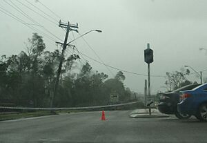
People in Tully said the town was "a scene of mass devastation." Many homes were completely destroyed by strong winds. Many other homes that were not destroyed had severe damage to their outside walls or roofs. By morning, reports from Tully said that about 90% of the buildings on the main street were badly damaged. The high school in Tully was destroyed and had to be rebuilt.
Other Impacts and Aftermath
An evacuation center in Innisfail started to flood as Yasi's worst impacts arrived. People there were trying to block water from coming in. They were also worried about the building's windows, which bent in winds over 200 km/h (124 mph). In Townsville, many roofs were ripped off buildings. They flew down the streets. Many windows were broken as people heard glass shattering throughout the night.
Many emergency calls were made by people trapped in their homes during the storm. However, police could not help because conditions were too dangerous. One example was six people trapped in an apartment building at Port Hinchinbrook near Cardwell. They could not be evacuated. The building was threatened by Yasi's storm surge, which was over 3 m (10 ft). The group was later reported to be safe.
Around 10:30 pm on February 2, Premier Bligh said that about 90,000 buildings, including evacuation centers, had no power. This number grew to 170,000 by morning. Officials said some people might be without power for over a month. The water supply system in Townsville failed, and there was only 24 hours of water left. Magnetic Island ran out of water in one day.
There were fears that the banana and sugar cane crops would be completely destroyed. Initial estimates said damage to sugar cane alone could reach A$505 million. On February 3, the total losses from the storm were estimated to be A$3.5 billion (US$3.54 billion). This made it the most expensive cyclone to ever hit Australia (not counting for inflation). By February 5, A$2 billion (US$2.03 billion) was confirmed lost in farming, mining, and local government. Another A$1 billion was lost in the tourism industry.
One person died from carbon monoxide poisoning. This happened because a portable generator was used in a closed space in Bambaroo near Ingham.
Two days after the storm hit, severe flooding from the rains cut off the Bruce Highway between Townsville and Ingham. This caused a 10-kilometer traffic jam. Many people who had left the damaged areas, including emergency workers, were stuck.
Rain and Flooding After the Storm
On February 5, the leftover parts of Yasi, as a tropical low, caused very heavy rain. For example, 140 mm (5.5 in) of rain was recorded in Terowie and Yongala. Flooding was widespread in towns in northern South Australia. It even reached Renmark on the River Murray. In north-west Victoria, Mildura had its highest daily rainfall ever, with 142 mm (5.6 in). Lyndhurst, a suburb of Melbourne, recorded 180 mm (7.1 in) of rain in 24 hours up to 9am AEDT on February 5.
On February 6, the BoM reported that Ex-Tropical Cyclone Yasi was 85 km (53 mi) north of Yulara. Heavy rains continued in the Alice Springs area. The heavy rain also continued in northern South Australia. Large areas kept getting rain. Hallett had a record rainfall of 98 mm (3.9 in). Strong winds with gusts over 90 km/h (56 mph) hit Marla and Coober Pedy. More than 100 mm (3.9 in) also fell at Arkaroola and Mt Dare.
Even one week after the flooding rains, some affected areas were completely cut off. At Challenger Gold Mine, 150 people were isolated. Emergency supplies had to be flown in. Cattle stations near Oodnadatta, Glendambo, and the world's largest at Anna Creek Station were all isolated.
The Australian Defence Force (ADF) helped with the recovery efforts. This was called Operation Yasi Assist. The ADF set up a special team, Joint Task Force 664, based in Townsville, to manage the operations on February 2, 2011.
See also
 In Spanish: Ciclón Yasi para niños
- 2010–11 Queensland floods
- March 2010 Queensland floods
Related tropical cyclones
- List of Queensland tropical cyclones
-
- Cyclone Althea (1971) - struck north of Townsville and caused significant damage
- Cyclone Larry (2006) - the previous costliest cyclone to impact Australia, also affecting the same area as Yasi
- Cyclones Tasha (2010), Oswald (2013) and Jasper (2023) – all struck similar areas as Yasi as lower intensity systems but caused devastating flooding.
- Cyclone Ita (2014) - the next severe tropical cyclone to strike the north coast of Queensland.
- Cyclone Tracy (1974) - one of the most destructive cyclones in Australia, Tracy and Yasi are often used as benchmarks due to both systems causing similar amounts of damage despite their vastly differing sizes.
 | Bessie Coleman |
 | Spann Watson |
 | Jill E. Brown |
 | Sherman W. White |


