
Abergowrie, Queensland facts for kids
Quick facts for kids AbergowrieQueensland |
|||||||||||||||
|---|---|---|---|---|---|---|---|---|---|---|---|---|---|---|---|

Abergowrie
Location in Queensland
|
|||||||||||||||
| Population | 305 (2021 census) | ||||||||||||||
| • Density | 0.9958/km2 (2.579/sq mi) | ||||||||||||||
| Postcode(s) | 4850 | ||||||||||||||
| Area | 306.3 km2 (118.3 sq mi) | ||||||||||||||
| Time zone | AEST (UTC+10:00) | ||||||||||||||
| LGA(s) | Shire of Hinchinbrook | ||||||||||||||
| State electorate(s) | Hinchinbrook | ||||||||||||||
| Federal Division(s) | Kennedy | ||||||||||||||
|
|||||||||||||||

Abergowrie is a small town and area in Queensland, Australia. It is part of the Shire of Hinchinbrook. In 2021, about 305 people lived in Abergowrie.
Contents
Exploring Abergowrie's Geography
This town is located where the Herbert River and Gowrie Creek meet. It's a beautiful spot in nature.
Mountains Around Abergowrie
Abergowrie is surrounded by several mountains. Here are some of them:
- Boulder Hill (145 meters high)
- Duncan Bluff (977 meters high)
- Mount Cadillah (188 meters high)
- Mount Echo (622 meters high)
- Mount Graham (834 meters high)
- Mount Westminster Abbey (926 meters high)
- Slopeaway (365 meters high)
Abergowrie's Past: A Look at History
Let's discover how Abergowrie came to be and what important events happened here.
Indigenous Language and Land
The Gugu Badhun language is an Aboriginal language from North Queensland. This language was spoken in areas like Charters Towers Region, Greenvale, and the Upper Burdekin River area, including Abergowrie.
How Abergowrie Got Its Name
The town is named after a property called Abergowrie. James Atkinson chose this name in 1883. He combined the Celtic word aber, which means "where rivers meet," with "gowrie" from Gowrie Creek. This name perfectly describes the town's location near the meeting of two waterways.
St Teresa's College: A School's Journey
In 1933, a special Catholic farm school began in Abergowrie. It was built on a large piece of land next to the Herbert River. Boys could take a two-year course to learn how to be farmers.
The school officially opened on March 1, 1934. It was run by the Christian Brothers. Today, this school is known as St Teresa's College.
Farming and Development After World War II
After World War II, a plan was made to help soldiers returning home. Abergowrie was chosen as a place where 300 farms could be set up. Sugarcane was the main crop they planned to grow.
Instead of building a sugar mill, a special tramway was built. This tramway helped transport the harvested sugarcane from Abergowrie to the Victoria sugar mill near Ingham.
Abergowrie's Post Office and School
Abergowrie had its own Post Office, which opened on May 1, 1953. It served the community for many years before closing in 1974.
Abergowrie State School also opened its doors on February 23, 1953, providing education for local children.
Who Lives in Abergowrie?
Let's look at the people who call Abergowrie home.
Population in 2016
In 2016, Abergowrie had 438 residents. About 31% were female and 69% were male. Around 30.8% of the people were Indigenous Australians. The average age was 32 years old. Most people (92.5%) were born in Australia. Other countries of birth included Papua New Guinea, Italy, and Fiji. English was the main language spoken at home by 77.9% of residents.
Population in 2021
By 2021, the population of Abergowrie was 305 people. About 39.9% were female and 60.1% were male. Around 10.5% were Indigenous Australians. The average age had risen to 47 years. Most people (84.6%) were born in Australia. Other countries of birth included Fiji, South Africa, Papua New Guinea, and Italy. English was spoken at home by 81.0% of residents. Other languages included Yumplatok (Torres Strait Creole), Spanish, Fijian, and Italian.
Learning in Abergowrie: Schools and Education
Abergowrie has schools that help young people learn and grow.

Abergowrie State School
Abergowrie State School is a government primary school for students from Prep to Year 6. It is located at 5 Venables Road. In 2018, the school had 8 students and 2 teachers.
St Teresa's College
St Teresa's College is a Catholic high school for boys, covering Years 7 to 12. It is located at 3819 Abergowrie Road. In 2018, the college had 190 students and 35 teachers.
There is no government high school directly in Abergowrie. The closest one is Ingham State High School, located in the nearby town of Ingham.
Community Groups
Queensland Country Women's Association
The Abergowrie-Long Pocket branch of the Queensland Country Women's Association (QCWA) meets at 2346 Abergowrie Road in Long Pocket. This group helps women in rural areas and supports their communities.
Images for kids
-
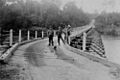
Abergowrie Bridge over the Herbert River on the road from Ingham to Abergowrie, Queensland, ca. 1934
-
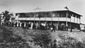
St Theresa's Agricultural College, Abergowrie, Queensland, circa 1932
