Stonewall, Mississippi facts for kids
Quick facts for kids
Stonewall, Mississippi
|
|||
|---|---|---|---|
|
|||

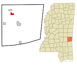
Location of Stonewall, Mississippi
|
|||
| Country | United States | ||
| State | Mississippi | ||
| County | Clarke | ||
| Government | |||
| • Type | Mayor/Alderman | ||
| Area | |||
| • Total | 2.66 sq mi (6.90 km2) | ||
| • Land | 2.65 sq mi (6.88 km2) | ||
| • Water | 0.01 sq mi (0.02 km2) | ||
| Elevation | 230 ft (70 m) | ||
| Population
(2020)
|
|||
| • Total | 879 | ||
| • Density | 331.07/sq mi (127.81/km2) | ||
| Time zone | UTC-6 (Central (CST)) | ||
| • Summer (DST) | UTC-5 (CDT) | ||
| ZIP code |
39363
|
||
| Area code(s) | 601 | ||
| FIPS code | 28-70760 | ||
| GNIS feature ID | 0678313 | ||
Stonewall is a small town located in Clarke County, Mississippi, in the United States. In 2010, about 1,088 people lived there. It's a quiet place with a history tied to cotton.
Contents
History of Stonewall
How Stonewall Got Its Name
The town of Stonewall was named after a famous Confederate Army General, Stonewall Jackson. This happened around the time the town was first developing.
The Cotton Mill Era
A large cotton mill was built in Stonewall in 1868. This mill became the town's main industry for many years. It provided jobs for a lot of people. From 1962, the mill was run by a company called Burlington Industries. However, in 2002, Burlington Industries decided to close the Stonewall plant. This meant that about 850 people lost their jobs, which was a big change for the town.
Geography of Stonewall
Location and Nearby Areas
The Chickasawhay River flows along the western edge of Stonewall. This river forms a natural border for the town. You can find the town of Enterprise about 3 miles (5 km) to the northwest, along Mississippi Highway 513. Quitman, which is the main town for the county, is about 9 miles (14 km) to the southeast.
Size of the Town
According to the United States Census Bureau, Stonewall covers a total area of about 2.66 square miles (6.9 square kilometers). Most of this area is land, with only a very small part, about 0.01 square miles (0.02 square kilometers), being water.
Population and People
How Many People Live Here?
The number of people living in Stonewall has changed over the years. Here's a look at the population from different census counts:
| Historical population | |||
|---|---|---|---|
| Census | Pop. | %± | |
| 1880 | 145 | — | |
| 1950 | 1,015 | — | |
| 1960 | 1,126 | 10.9% | |
| 1970 | 1,161 | 3.1% | |
| 1980 | 1,345 | 15.8% | |
| 1990 | 1,148 | −14.6% | |
| 2000 | 1,149 | 0.1% | |
| 2010 | 1,088 | −5.3% | |
| 2020 | 879 | −19.2% | |
| U.S. Decennial Census | |||
Stonewall's Population in 2020
The most recent count in 2020 showed that 879 people lived in Stonewall. These people made up 405 households, with 210 of those being families.
Most of the people in Stonewall are White (about 64.5%). The next largest group is Black or African American (about 32.9%). There are also smaller numbers of Native American, multiracial, and Hispanic or Latino residents.
Education in Stonewall
Students in Stonewall attend schools within the Quitman School District. For those who want to continue their education after high school, the county is part of the zone for Jones College.
Notable People from Stonewall
- Herman Dunlap – A baseball player who played as an outfielder in the Negro league.
- Danny Pearson – A talented person who wrote and sang songs.
See also
 In Spanish: Stonewall (Misisipi) para niños
 | Delilah Pierce |
 | Gordon Parks |
 | Augusta Savage |
 | Charles Ethan Porter |


