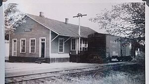
Stovall, North Carolina facts for kids
Quick facts for kids
Stovall, North Carolina
|
|
|---|---|

Location of Stovall, North Carolina
|
|
| Country | United States |
| State | North Carolina |
| County | Granville |
| Incorporated | 1883 |
| Named for | John W. Stovall |
| Area | |
| • Total | 1.05 sq mi (2.71 km2) |
| • Land | 1.05 sq mi (2.71 km2) |
| • Water | 0.00 sq mi (0.00 km2) |
| Elevation | 476 ft (145 m) |
| Population
(2020)
|
|
| • Total | 324 |
| • Density | 309.46/sq mi (119.53/km2) |
| Time zone | UTC-5 (Eastern (EST)) |
| • Summer (DST) | UTC-4 (EDT) |
| ZIP code |
27582
|
| Area code(s) | 919 |
| FIPS code | 37-65320 |
| GNIS feature ID | 2406673 |
Stovall is a small town located in Granville County, North Carolina, in the United States. In 2010, about 418 people lived there.
Contents
History
Stovall has a rich history with several important places. Some of these places are so special that they are listed on the National Register of Historic Places. This list helps protect buildings and sites that are important to American history.
The historic places in Stovall include:
- Abrams Plains
- Maurice Hart House
- Hill Airy
- John W. Stovall Farm
A very important person named John Penn once lived near Stovall. He was one of the people who signed the United States Declaration of Independence. This document declared that the United States was a free country. His old home and grave site are now cared for by the Daughters of the American Revolution (DAR). This group works to preserve history and promote patriotism.
Geography
Stovall is a small town when it comes to its size. According to the United States Census Bureau, the town covers about 1.0 square mile (2.7 square kilometers) of land. There is no water area within the town limits.
Stovall is part of the Sassafras Fork voting area in Granville County. This helps organize local elections.
Demographics
| Historical population | |||
|---|---|---|---|
| Census | Pop. | %± | |
| 1910 | 305 | — | |
| 1920 | 414 | 35.7% | |
| 1930 | 415 | 0.2% | |
| 1940 | 415 | 0.0% | |
| 1950 | 410 | −1.2% | |
| 1960 | 570 | 39.0% | |
| 1970 | 405 | −28.9% | |
| 1980 | 417 | 3.0% | |
| 1990 | 409 | −1.9% | |
| 2000 | 376 | −8.1% | |
| 2010 | 418 | 11.2% | |
| 2020 | 324 | −22.5% | |
| U.S. Decennial Census | |||
In 2010, the town of Stovall had 418 people living in 170 households. This means there were about 418 people for every square mile.
The people living in Stovall came from different backgrounds. About 54.5% were White, and 41.4% were African American. A small number, 4.1%, were from other races. About 3.8% of the population identified as Hispanic or Latino.
When looking at age groups, about 24.6% of the people were under 18 years old. About 19.6% were 65 years old or older. This shows a mix of younger and older residents in the town.
The average income for a household in Stovall was about $35,313 in 2010. The average income for families was higher, around $55,938. The average income per person in the town was $24,117. About 10.9% of the total population lived below the poverty line. This included about 12.5% of children under 18.
See also
 In Spanish: Stovall (Carolina del Norte) para niños


