
Strait of Otranto facts for kids
Quick facts for kids Strait of Otranto |
|
|---|---|

Strait of Otranto
Location in Europe
|
|

Map showing the location of the Strait of Otranto
|
|
| Coordinates | 40°13′10″N 18°55′32″E / 40.21944°N 18.92556°E |
| Basin countries | Italy, Albania |
| Average depth | 18 m (59 ft) |
The Strait of Otranto is a narrow waterway that connects two important seas. It links the Adriatic Sea with the Ionian Sea. This strait also separates the countries of Italy and Albania.
At its narrowest point, near Punta Palascìa in Italy, it is less than 72 kilometres (45 mi) wide. The strait gets its name from the Italian city of Otranto, which is located nearby.
History of the Strait
World War I Importance
During World War I, the Strait of Otranto was very important for military reasons. The navies of Italy, France, and Great Britain worked together. They used the strait to block the Austro-Hungarian Navy. This prevented Austro-Hungarian ships from easily entering the wider Mediterranean Sea.
Rules for Boats
In 2006, the Albanian government made a new rule about boats. They said that motor-powered sailing boats could not be used on Albania's lakes, rivers, or seas. This rule was put in place to help stop organized crime.
Some types of boats were still allowed. These included government boats, foreign-owned boats, fishing boats, and jet boats. In 2010, this rule was extended for three more years, until 2013. The goal was to make sure people crossed the strait safely and legally.
Images for kids
-

Bay of Vlora
-
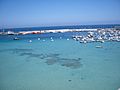
Otranto harbour
-
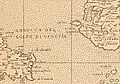
The Strait of Otranto on a map from the early 17th century


See also
 In Spanish: Canal de Otranto para niños
