
Stratton, Colorado facts for kids
Quick facts for kids
Stratton, Colorado
|
|
|---|---|

Looking north along Colorado Avenue (2019)
|
|

Location within Kit Carson County and Colorado
|
|
| Country | United States |
| State | Colorado |
| County | Kit Carson |
| Incorporated | April 15, 1917 |
| Government | |
| • Type | Statutory Town |
| Area | |
| • Total | 0.51 sq mi (1.33 km2) |
| • Land | 0.51 sq mi (1.33 km2) |
| • Water | 0.00 sq mi (0.00 km2) |
| Elevation | 4,413 ft (1,345 m) |
| Population
(2020)
|
|
| • Total | 656 |
| • Density | 1,286/sq mi (493.2/km2) |
| Time zone | UTC−7 (MST) |
| • Summer (DST) | UTC−6 (MDT) |
| ZIP Code |
80836
|
| Area code | 719 |
| FIPS code | 08-74485 |
| GNIS ID | 204821 |
Stratton is a small town located in Kit Carson County, Colorado, United States. It's known as a "statutory town," which means it follows specific rules set by the state of Colorado for how towns are run. In 2020, about 656 people lived there. The town was named after Winfield Scott Stratton, a famous gold miner and generous person.
Contents
Discovering Stratton's Location
Stratton is found at a specific point on the map: 39.302976 degrees North and -102.604272 degrees West. This helps us pinpoint its exact spot in the world.
The town covers a total area of about 0.5 square miles (1.3 square kilometers). All of this area is land, meaning there are no large lakes or rivers within the town limits.
Stratton's Weather and Climate
Stratton experiences a climate with warm summers and cold winters. The hottest month is usually July, with average temperatures around 75.1°F (23.9°C). The coldest month is January, with average temperatures around 30.4°F (-0.9°C).
The town gets most of its rain in the spring and summer months, especially in May, June, July, and August. Snowfall is common in the winter, with the most snow typically falling in November and March.
How Many People Live in Stratton?
The number of people living in Stratton has changed over the years. Here's a quick look at the population counts from different years:
| Historical population | |||
|---|---|---|---|
| Census | Pop. | %± | |
| 1920 | 421 | — | |
| 1930 | 507 | 20.4% | |
| 1940 | 623 | 22.9% | |
| 1950 | 720 | 15.6% | |
| 1960 | 680 | −5.6% | |
| 1970 | 790 | 16.2% | |
| 1980 | 705 | −10.8% | |
| 1990 | 649 | −7.9% | |
| 2000 | 669 | 3.1% | |
| 2010 | 658 | −1.6% | |
| 2020 | 656 | −0.3% | |
| U.S. Decennial Census | |||
Learning in Stratton
Students in Stratton attend Stratton Senior High School. This school helps young people get their education and prepare for their future.
Getting Around Stratton
Stratton is connected to other places by important roads. These include:
- Interstate 70: A major highway that crosses the United States.
- U.S. Highway 24: Another important road that runs through Colorado.
Images for kids
-
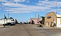
A view looking north along Colorado Avenue in Stratton.
-
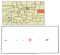
A map showing Stratton's location within Kit Carson County and Colorado.
See also
 In Spanish: Stratton (Colorado) para niños
